
Range Wasatch Range | Traversed by Interstate 80 | |
 | ||
Location Salt Lake / Summit counties, Utah, United States Similar Wasatch Range, Millcreek Canyon, Big Cottonwood Canyon, Little Cottonwood Canyon, Bonneville Shoreline Trail | ||
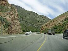
Parley's Canyon is a canyon located in the U.S. state of Utah. The canyon provides the route of Interstate 80 (I-80) (and previously the Lincoln Highway, U.S. Route 40, and a railroad) up the western slope of the Wasatch Mountains and is a relatively wide, straight canyon other than near its mouth. The mountain pass at the top of the canyon is known as Parley's Summit. With an elevation of 7,120 feet (2,170 m), the pass is the highest point along I-80 in the state of Utah. Both features are named for Parley P. Pratt, an early settler of the Salt Lake Valley and Mormon leader who surveyed the area to find a better transportation route through the Wasatch Mountains than the previous route which traversed Emigration Canyon.
Contents
Map of Parley's Canyon, Utah 84108, USA
Description
Parley's Canyon begins where I-215 merges into I-80 in Salt Lake City and ends at Parley's Summit. The lower part of the canyon is relatively twisty and narrow and had to be dynamited to make way for I-80. Despite this, the interstate remains six or more lanes wide throughout the canyon; it is built over Parley's Creek in many places. Work is also underway to extend the Parley's Trail multi-use path through this segment to improve non-motorized access.
The canyon widens dramatically near Mountain Dell Dam and Utah State Route 65 (SR-65) splits from the freeway (which turns southeast temporarily) to provide access to Morgan County to the northeast. SR-65 also provides a connection to a local road leading over the ridge to Emigration Canyon in the same area where the Mormon trail crossed into that canyon. Little Dell Dam can be seen higher up on the side of Parley's Canyon in this area. As the freeway turns back toward the east, there is also an exit for the road leading up Lambs Canyon (a side canyon of Parley's Canyon).
The area around Parley's Summit is part of the Summit Park census-designated place (CDP). However, this area is more commonly referred to as Jeremy Ranch or Parley's Summit. Here the canyon is wide enough to form large communities along the sides of the freeway along the gentle mountain slopes. On the other side of the summit the freeway continues into the Snyderville Basin, which is where the popular resort town of Park City is located. Also within the basin is the ski jump built for the 2002 Winter Olympic Games and the large shopping district that has manifested itself around Kimball Junction.
History
The canyon receives its name from Parley P. Pratt who was assigned to explore the canyon, called Big Canyon at the time, and to build a toll road, called the Golden Pass Toll Road. Construction on the road started in 1848 and was completed in 1850. The road through Parley's Canyon became the primary route into the Salt Lake Valley, surpassing the original route through Emigration Canyon. The canyon was used by a narrow gauge spur line owned by the Denver & Rio Grande Western Railroad from Salt Lake to Park City (the Salt Lake and Park City Railway). However, with its steep grades the line was unable to compete with the Union Pacific's line, (via Coalville, connecting to the UP main at Echo). Although the D&RG considered rebuilding their line to standard gauge, the line was abandoned before these plans were implemented. Some remnants of the D&RG line through Parley's Canyon, namely the cuts for the horseshoe curves, are in use by local roads and visible off the shoulder of the freeway.