
Population 263 (2011) Sovereign state United Kingdom | Civil parish Parham | |
 | ||
Parham is a village and civil parish in the Suffolk Coastal district of Suffolk in eastern England. Located seven miles north of Woodbridge, in 2005 it had a population of 300, reducing to 263 at the 2011 Census, according to the 2011 census, there were 129 males and 134 females living within the parish.
Contents
Map of Parham, UK
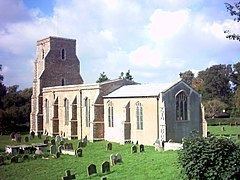
The flint-built parish church of St Mary, though restored in 1886, dates from the late 14th Century and was likely built for William de Ufford. The Rood screen is 15th Century. The aviator Ray Hanna is buried in the churchyard. Parham is located on the B1116.
Parham Airfield Museum is located nearby. The airfield museum is located on the outskirts of the village, and is a volunteer ran museum celebrating the 390th bomb group that were stationed in the village during the second world war. The runway of the airfield is no longer there and is owned by local farms but the control tower still stands and is now the home to the museum. The control tower was shot up and abandoned after the Americans held a riotous party before they left in August of 1945. in 1976, a group of enthusiasts decided to restore the now decaying building and open the museum as a tribute to those who served in it. It took 5 years of work to restore the building and open the museum and fully opened in 1981 dedicated as " the 390th Bombardment Group Memorial Air Museum of the USAAF " In the museum are a rare collection of second world war aircraft engines, parts of allied and german aircraft, uniforms, documents and photos and other memorabilia relevant to the US 8th airforce, who also served here. Many of the exhibits have been kindly donated to the museum.
Parham railway station, on the Framlingham Branch, was shut to passenger traffic in November 1952.
Occupation Structure
The Occupational structure (1881) of Parham is very agricultural based although there are a lot of unspecified or unknown, there were 77 males and 3 females working in farming and agriculture in 1881 There was 1 male who was employed in the armed forces as seen in the occupational structure graph below. There were 2 males employed in the conveyance of goods, men and messages This is different to today as there isn't a post office in the village. There were 2 female dominated positions in the village in 1881; these were Domestic Offices or Services, in which 1 male and 19 females worked, and Education and religion in which 1 male and 15 females were employed.
Population
Population of Parham 1801 -2011 shows that Parham's population has been declining, going from 399 in 1801, to 263 in 2011. There has been some fluctuation in the population of Parham however, rising to a high of 532 in 1851 after rising steadily in the years before. Since 1851, the population steadily declined, as seen in the graph, only rising again in the 1951, after the baby boom after the second world war ended. The population is the lowest it has been recorded.
Religion
The religion is Parham is mainly that of Christian, this is due to the Church of England church in the village, in 2001, there were 245 people from Parham who identified themselves as a Christian, which then dropped to just 171 in the 2011 census. there was 3 people in the 2001 census, who identified as a religion described in the census as "other", this then dropped to 1 in the 2011, this drop could be due to people identifying with a different religion. People identifying as having no religion has increased, from 28 in 2001, up to 72 in 2011. In 2001 31 people did not state any religion, whether they believed in one or not. in 2011 this number fell to 19.