
Country Spain Comarca Ripollès Elevation 1,226 m Local time Thursday 5:57 AM Province Province of Girona | Autonomous Community Catalonia Website www.pardines.cat Area 31 km² Population 155 (2014) | |
 | ||
Weather 2°C, Wind W at 11 km/h, 83% Humidity | ||
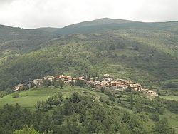
Pardines ([pərˈðinəs]) is a municipality in the comarca of Ripollès, province of Girona, Catalonia, Spain.
Contents
Map of Pardines, 17534, Province of Girona, Spain
The highest point in the municipality is Puig Cerverís (2,202 m). The municipality is bordered on the north by Queralbs and Vilallonga de Ter, on the east and south by Ogassa, and on the west by Ribes de Freser and Queralbs.
History
The name Pardines has its origins in the name parietinas, which means "building ruins." It is first documented in 839, in the act of consecration of Sant Ot d'Urgell. It was a possession of the counts of Cerdanya, the nobility of Sales, the monastery of Sant Martí de Canigó, and the counts of Barcelona.
Sights
References
Pardines, Girona Wikipedia(Text) CC BY-SA