
Basin area 13,643 km² | Length 510 km Mouth Três Marias Dam | |
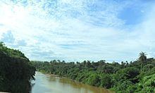 | ||
Rio paraopeba ainda um lugar de lazer
The Paraopeba River is a river in Brazil, flowing in the state of Minas Gerais. In the Tupi language 'Para" means "great river or sea", and "peba means"flat" . The full name therefore means something like "flat river".
The source of the river is situated south of the municipality Cristiano Otoni, Minas Gerais. The mouth is at the Três Marias Dam in the municipality Felixlandia in the same state. The length of the river is 546,5 km and its basin covers an area of 12.090 km² and 35 municipalities. The most important tributaries are the Macaúba River, the Camapuã River and the Manso River (Minas Gerais). The Paraopeba River is one of the most important tributaries of the São Francisco River, ensuring the yearlong navigability of that river.
References
Paraopeba River Wikipedia(Text) CC BY-SA