Country Italy Demonym(s) Paolani Local time Wednesday 7:43 AM | Elevation 94 m (308 ft) Time zone CET (UTC+1) Population 16,914 (31 Dec 2014) Postal code 87027 | |
 | ||
Weather 10°C, Wind W at 8 km/h, 89% Humidity | ||
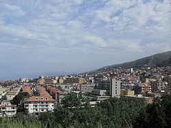
Paola is a town and comune in the province of Cosenza in the Calabria region of southern Italy.
Contents
- Map of 87027 Paola Province of Cosenza Italy
- Geography
- History
- Main sights
- Personalities
- Transport
- Twin towns
- References
Map of 87027 Paola Province of Cosenza, Italy
Geography
Paola is on the eastern shore of the Tyrrhenian Sea. Nearby towns include Fuscaldo to the north, San Lucido to the south, and (beyond a ridge) Montalto Uffugo to the east and San Benedetto Ullano to the northeast.
History
In July 1555, the Beylerbey of the Mediterranean, Turgut Reis, captured the city.
In August 1943, the middle of World War II, while almost all the citizens of the city were hiding from the air raids by Allied bombers inside the Monastery of St. Francis of Paola, an 80 kg (176 lb) iron-core bomb fell right in the middle of the agglomeration, but did not detonate, a fact widely reported as a miracle. The reason behind the bombing was the presence of Carlo Scorza, secretary of the National Fascist Party, second only to Mussolini.
Main sights
Saint Francis Sanctuary, Del'Annunziata church dome, S. S. Rosario church, Ipogeo di Sotterra church. Feast of Saint Francis, May 1–4.
Personalities
Paola is the home of St. Francis of Paola and houses a world-famous Catholic sanctuary dedicated to the saint.
Transport
Paola railway station, opened in 1895, forms part of the Battipaglia–Reggio di Calabria railway, and is also a terminus of a secondary line, the Paola–Cosenza railway.
