
Country United States County Inyo County Local time Tuesday 1:56 PM | State California Elevation 587 m | |
 | ||
Weather 22°C, Wind S at 34 km/h, 47% Humidity | ||
Panamint Springs is an unincorporated community in Inyo County, California. It lies at an elevation of 1926 feet (587 m).
Contents
Map of Panamint Springs, CA, USA
Location
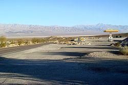
Panamint Springs is located along State Route 190 (SR190) between Old Toll Road and Panamint Valley Road. The community features a motel, restaurant, and the last gas station for many miles in either direction on SR190.
Although not official by the Board of Geographic Names, Caltrans calls the SR190/Panamint Valley Road intersection, Panamint Junction. The junction is about 2.5 driving miles east of Panamint Springs. Towne Pass, a landmark when traveling to Death Valley, is 13.9 driving miles east on SR190. Beyond the pass, SR190 descends about 5,000 feet (1,500 m) to the dry bed of Lake Manly.
The Darwin Falls Wilderness, a U.S. Wilderness Area, is located just west of the settlement. The nearby area also features the Darwin Falls, a small but scenic waterfall, grotto and creek that are the only year-round water supply in the driest part of North America; despite the similarly named wilderness, the falls are located in and administered by Death Valley National Park. The dirt road entryway to the trail to Darwin Falls is located ¼ mile west of the settlement.
NAD27 latitude and longitude for Panamint Springs are 36°20′23″N 117°28′04″W and the feature ID number is 1661186. The elevation is identified as being 1,940 feet (590 m) AMSL. The ZIP Code is 93545. The community is inside area code 760.
History
A post office operated at Panamint Springs from 1940 to 1946.
Similar name
The similar-sounding ghost town Panamint, California, also known as Panamint City, is located in Surprise Canyon about 25.8 miles (41.5 km) at 127.1 degrees off true north.
Politics
In the state legislature, Panamint Springs is in the 8th Senate District, represented by Republican Tom Berryhill, and the 26th Assembly District, represented by Republican Devon Mathis.
Federally, Panamint Springs is in California's 8th congressional district, represented by Republican Paul Cook.