
 | ||
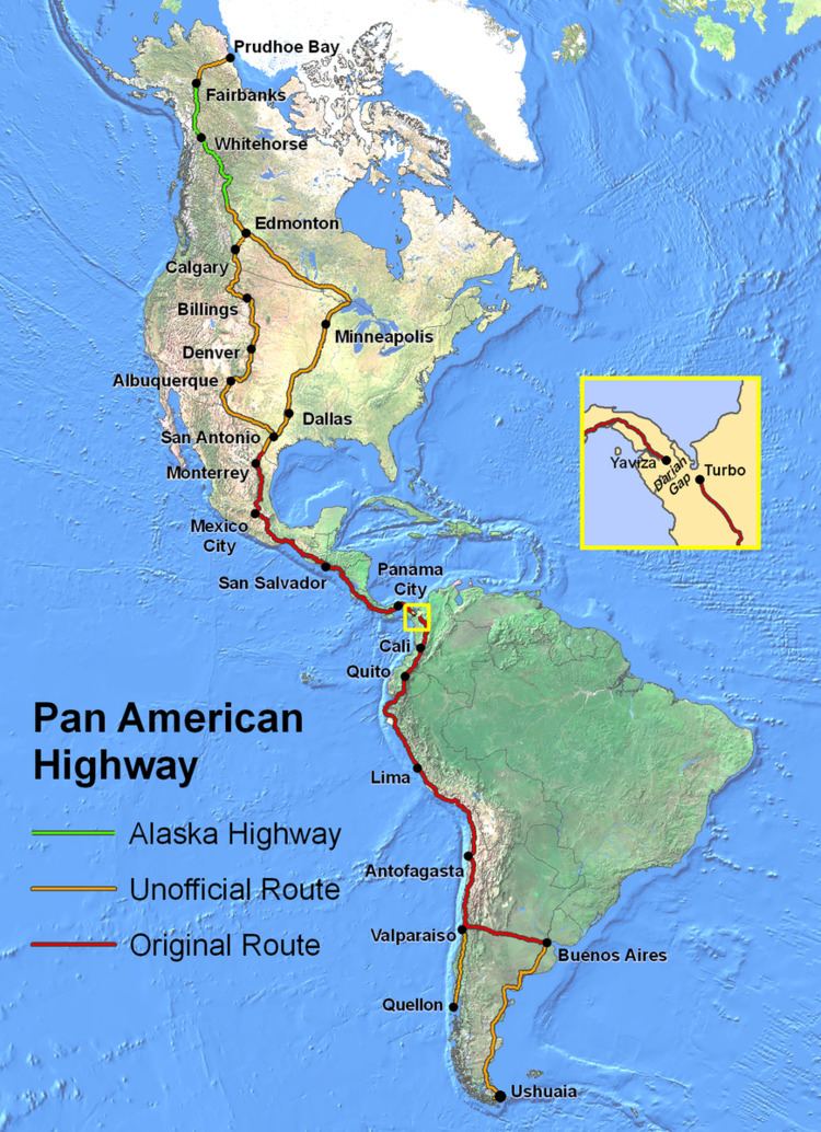
The Pan-American Highway route in North America is the portion of a network of roads nearly 48,000 km in length which travels through the mainland nations of the Americas.
Contents
- United States Alaska
- Canada
- United States Contiguous
- Mexico
- Guatemala
- El Salvador
- Honduras
- Nicaragua
- Costa Rica
- Panama
- References
No definitive length of the Pan American Highway exists because the Canadian government has never officially defined any specific route as being part of the Pan-American Highway, while in the U.S., the Federal Highway Administration(FHA) has designated the entire Interstate Highway System part of the Pan-American Highway System, although this has not yet been reinforced by any official highway signage. Mexico officially has many branches connecting to various interstate highways at the U.S. border. However, the total length of the North American portion of the highway following the most direct route is roughly 26,000 km (16,000 mi).
Partial lengths (with references):
United States (Alaska)
Alaska
The Pan-American Highway unofficially begins in Prudhoe Bay, Alaska near Deadhorse. Traveling south to Fairbanks, Alaska follows the length of the Dalton Highway (Alaska Route 11) and Alaska Route 2.
From Alaska's third largest city, the Pan-American Highway and the Alaska Highway are one and the same, following Alaska Route 2 southeast to the Canada–United States border southeast of Northway, Alaska, and adjacent to the Tetlin National Wildlife Refuge.
Note: The Pan-American Highway reenters the U.S., potentially in several locations along the U.S.-Canada border.
Canada
Yukon Yukon Road Map
Crossing the border into Canada, Alaska Highway 2 turns into Yukon Highway 1. The first significant settlement along the way is Beaver Creek, Yukon.
At Haines Junction, where it meets Yukon Highway 3, Yukon Highway 1 turns east toward Whitehorse, the capital of the Yukon Territory.
Through most of Whitehorse, Yukon Highway 2 and Yukon Highway 1 share an alignment. Yukon Highway 1 cuts southeast toward Marsh Lake, Yukon while Yukon Highway 2 cuts south to Skagway, Alaska. Eventually, Yukon Highway 1 intersects with Yukon Highway 8 and Yukon Highway 7 at Jake's Corner, Yukon; the highways continues on Yukon 1 east-northeast from this junction.
At Johnson's Crossing, Yukon Highway 1 meets Yukon Highway 6 and travels southeast through Teslin, Yukon. The highway continues on Yukon 1 as it crosses over into British Columbia. After several miles, the highway reenters the Yukon (once again as Highway 1) and continues on Yukon 1 southeast of Watson Lake until it once again enters British Columbia as B.C. Highway 97.
British Columbia British Columbia Road Map
After travelling about 8 km (5.0 mi) past the B.C.-Yukon border, the Pan-American Highway reaches the first settlement in British Columbia at Lower Post. After travelling about 32 km (20 mi) roughly east, the highway once again reenters the Yukon for roughly 8 miles (13 km). The highway then re-enters British Columbia (as B.C. 97) for the final time. The Pan-American Highway continues south to southeast through a long, uninhabited stretch until it passes through the villages of Fireside and Coal River, then run east parallel to the Rabbit River.
Roughly 13 km (8.1 mi) south of Liard River is Muncho Lake Provincial Park. The highway continues on B.C. Highway 97 as it passes through Toad River Post. Eventually it passes through Summit Lake, which is nested between Stone Mountain and Mount Saint George. Further down the road, B.C. Highway 97 intersects with B.C. Highway 77; the highway continues along B.C. 97 east to Fort Nelson.
From Fort Nelson, the highway travels south for roughly 290 km (180 mi) until it reaches Fort St. John.
Once the Pan-American Highway reaches Fort St. John, the highway traveler has already nearly completed a large stretch of their travels through North America. The highway continues on B.C. Highway 97 southeast for another 60 km (37 mi) to reach the end of the Alaska Highway at Dawson Creek.
Canada's length of the Pan-American Highway is neither official nor defined beyond the end of the Alaska Highway.
United States (Contiguous)
Note: The Pan-American Highway is almost never referred to by name in the U.S. because of its correlation with the Interstate Highway System rather than any singular route.In 1932, a bill introduced to the U.S. Congress proposed, among other roads, a route from Duluth, Minnesota, to Laredo, Texas, to connect with the Pan-American Highway in Mexico; this route probably followed today's Interstate 35. When the section of Interstate 35 in San Antonio, Texas was built, it was named the Pan Am Expressway, as it lies along this route. However, this route was never singularly named the Pan-American Highway.
Interstate 25 in Albuquerque is named the Pan-American Freeway, and it along with part of Interstate 10 and U.S. Route 85 are officially parts of the CanAm Highway.
U.S. Route 81 is claimed to be part of the Pan American Highway from Wichita, Kansas to Watertown, South Dakota where it runs separately from Interstate 29.
Interstate 69 from the Canada–United States border in Michigan to the Mexico–United States border in south Texas has been referred to as the NAFTA Superhighway, which, when completed, will link to an official branch of the Pan-American Highway after crossing the border between Laredo, Texas and Nuevo Laredo, Tamaulipas.
Mexico
The Pan-American Highway unofficially has four terminals entering into Mexico. It is more generally known as the Inter-American Highway in that country and officially begins at the border crossing between Laredo, Texas, and Nuevo Laredo, Tamaulipas.
In Nuevo Laredo, the Mexican Federal Highway 85 splits into two routes to Monterrey, the alternate being Mexican Federal Highway 85D which has a toll of MXN$177. Nuevo Laredo is a city with 348,387 inhabitants. The city is considered Latin America's largest inland port with four international bridges into the USA. Monterrey is located some 225 km from Nuevo Laredo.
Monterrey the third largest city in Mexico. Monterrey is a largely industrial city with approximately 4.5 million people. The Pan-American Highway continues south on Mexican Federal Highway 85, which is a divided limited-access highway until just past the village of Hualahuises. This is the beginning of an undivided stretch of the Pan-American Highway which parallels then cuts through the Sierra Madre Oriental mountains.
From Monterrey to Hualahuises is about 105 km (65 mi). The highway continues south as Mexico 85 for another 140 km (87 mi) until it reaches Ciudad Victoria. About 15 miles (24 km) past the village of Linares, the Pan-American or Inter-American Highway enters the state of Tamaulipas.
From Ciudad Victoria, the highway continues south as Mexico 85 for about 130 km (81 mi) to the next town, Ciudad Mante. About 90 km (56 mi) south of Ciudad Mante is the town of Ciudad Valles; about halfway to Ciudad Valles, the Pan-American Highway enters the state of San Luis Potosí.
From Ciudad Valles to Zimapán is about 200 km (120 mi) of winding mountain road; Zimapán is in the state of Hidalgo. From Zimapán to the Hidalgo state capital of Pachuca is about 122 km (76 mi).
Upon entering Pachuca, the Pan-American Highway becomes once again a divided limited-access route. About 40 km (25 mi) southwest of Pachuca, Mexico 85 has an alternate toll route Mexican Federal Highway 85D as it enters the state of México; for about another 40 km (25 mi). Teotihuacan ruins exist near the roadside along this stretch of the highway. The highway continues another 32 to 40 km (20 to 25 mi) before entering the Mexico City metropolitan area in the suburb of Ecatepec de Morelos.
The Pan-American Highway (as Mexico Highway 85D) enters Mexico City. Downtown Mexico City can be bypassed using Mexico Highway 136 (a divided limited-access route) and Mexico Highway 115, which reconnects to Mexico Highway 95D south of the Mexican Federal District.
As the Pan-American Highway continues south of Mexico City and the Distrito Federal (Federal District), the road arrives in the city of Cuernavaca about 30 miles (48 km) south of the Mexican capital. Here, the Inter-American Highway section of the Pan-American Highway heads east along Federal Highway 190 through the state of Puebla; for about 32 km (20 mi), it is a limited-access divided highway. The route then reverts to an undivided highway and enters the state of Oaxaca. From Huajuapan de León to the Oaxaca state capital of Oaxaca is about 140 km (87 mi).
From the city of Oaxaca, it continues southeast as Mexico Highway 190 for about 230 km (140 mi)to the village of Juchitán de Zaragoza . The Pan-American Highway is now in southern Mexico, which is a combination of small mountains, hills, and jungles. It is another 90 km (56 mi) to the border with the state of Chiapas and another trip across the Continental Divide.
From the Oaxaca-Chiapas state border, it is 160 km (99 mi) to the Chiapas state capital of Tuxtla Gutiérrez. Chiapas is an extremely impoverished region with relatively few services, especially outside of Tuxtla Gutiérrez. A large number of Chiapas residents are partly or completely of Mayan descent and do not speak Spanish, let alone English. Chiapas is also the home of the anti-Mexico City Zapatista Army of National Liberation rebel group. The Highway crosses the Mexico-Guatemala border at Ciudad Cuauhtémoc.
Guatemala
Upon crossing into Guatemala, Mexico Highway 190 becomes Central America Highway 1 and continues for about 80 km (50 mi) from the border village of La Mesilla to the city of Huehuetenango near the Maya ruins of Zaculeu. The Pan-American Highway once again crosses over the Continental Divide and into the Sierra de los Cuchumatanes mountains.
From Huehuetenango to Chimaltenango is roughly 160 km (99 mi). On the way to Chimaltenango, there are some Mayan ruins at Iximché just north of Tecpán Guatemala. From Chimaltenango, it is only about 35 to 40 km (22 to 25 mi) to Guatemala City.
Guatemala City is the capital and largest city in Guatemala with a population between 1 and 2.5 million people; it is also the largest city in Central America. Guatemala City has several attractions, such as the Centro Cívico (Civic Center), Centro Cultural Miguel Ángel Asturias (national theater), the Jardín Botánico (Botanical Garden), Lake Amatitlán (with a view of active volcanoes), the Mercado Central (Central Market with fruits and vegetables), Kaminal Juyú Mayan ruins, and the Zoológico La Aurora (Aurora Zoo).
From Guatemala City to Cuilapa is about 50 km (31 mi) and another 55 km (34 mi) to Jutiapa. The highway continues as CA Highway 1.
From Jutiapa, the Pan-American Highway approaches the border with El Salvador. It is 50 km (31 mi) to the border crossing at San Cristobal Frontera.
El Salvador
El Salvador is the smallest country (by area) along the route of the Pan-American Highway. After crossing into El Salvador at Candelaria de la Frontera, the Inter-American Highway continues on toward Santa Ana as Central America Highway 1. From the border crossing to Santa Ana is about 13 km (8.1 mi).
From Santa Ana to San Salvador is about 45 km (28 mi). At Nueva San Salvador, the traveler will pass near the Volcano de San Salvador.
San Salvador, with a population of 402,448, is the capital and largest city in El Salvador. Some attractions are the New World Museum, Dixon Hill Lighthouse, and Watling's Castle, which is an old pirate hangout.
From San Salvador to Cojutepeque is about 15 km (9.3 mi); following the highway southeast to San Miguel is about 65 km (40 mi). From San Miguel to the El Salvador-Honduras border is about 30 km (19 mi).
Honduras
From the border with El Salvador, the Pan-American Highway passes through Honduras. The highway's total distance in Honduras is about 148 km (92 mi).
From the border crossing to Nacaome is only about 40 km (25 mi). Just past Nacaome is a highway traveling north to Tegucigalpa, the capital of Honduras. It is about another 40 km (25 mi) to Choluteca, the fourth largest city in Honduras. From Choluteca to the border crossing just past San Marcos de Colón is about 68 km (42 mi).
Nicaragua
From the crossing at the Honduras-Nicaragua border, the highway continues as Central America Highway 1. From the border to the town of Ocotal is about 42 km (26 mi); from Ocotal to Estelí is about 58 km (36 mi).
Estelí to the village of Sébaco is about 46 km (29 mi); the Inter-American Highway turns from southeast to south towards Ciudad Darío, which is 15 km (9.3 mi) from Sébaco. From Ciudad Dario to the village of San Benito is 55 km (34 mi).
From San Benito, it is about 38 km (24 mi) to the Nicaraguan capital and largest city of Managua. Managua is located on the shores of Lake Managua and is about 56 km (35 mi) west of Lake Nicaragua. Attractions include the Plaza de la República, which includes a lakeside cathedral, the Palacio Nacional (National Palace), the Ancient footprints of Acahualinca (Huellas de Acahualinca) museum, and the Museo de la Revolución (Nicaragua) (Museum of the Revolution). From Managua south to the town of Jinotepe is about 50 km (31 mi).
Jinotepe to the town of Rivas is about 70 km (43 mi). Around this area the Highway is in view of the shores of Lake Nicaragua, which is the largest lake in Central America. From Rivas to the Nicaragua-Costa Rica border is about 35 km (22 mi).
Costa Rica
Costa Rica contrasts sharply to the other nations in Central America, as it is a so-called second-world developing country compared to its underdeveloped, poorer neighbor Nicaragua. Costa Rica is the second-smallest Central American country in area (after El Salvador). Its portion of the Pan-American Highway, however, is still a minimally maintained twisty two-lane road, at least between San José and the Nicaragua border. Soon after entering Costa Rica the highway separates two national parks, the Santa Rosa National Park to the west and Guanacaste National Park to the east.
From the Nicaragua-Costa Rica border to the town of Liberia is about 72 km (45 mi). In the region of Costa Rica, the Pan-American Highway runs just west of the Cordillera de Guanacaste (Guanacaste Mountains), which includes the active volcanoes of Rincón de la Vieja and Miravalles. While travelling through Costa Rica north of San Jose, the highway route is known as Costa Rica Highway 1 instead of CA Highway 1. From San Jose south to Panama, the highway route is known as Costa Rica Highway 2.
Liberia to the town of Barranca is about 105 km (65 mi). From Barranca, the Cordillera de Tilarán (Tilarán Mountains) can be seen from the Pan-American Highway. The Tilarán range includes Arenal, one of the world's most active volcanoes. From Barranca, the highway heads east across the mountains and the Continental Divide once again. From Barranca, it is roughly 70 km (43 mi) to the town of Alajuela.
After Alajuela the Cordillera Central (Central Mountains) come into view from the Inter-American Highway. The Central Mountains include four large volcanoes--Poás, Barva, Irazú and Turrialba. From Alajuela to San José is about 25 km (16 mi).
San José is the capital and largest city in Costa Rica. Although San José is more modern than other large Central American cities with its shopping malls, department stores, and even fast food restaurants, it also includes several museums. These include the Museo Nacional (National Museum), the Museo del Oro Precolombino (Museum of Pre-Columbian Gold), the Museo de Jade (Jade Museum), the Teatro Nacional (National Theatre), and the Mercado Central (Central Market; open air).
Leaving San José, the Pan-American Highway winds its way roughly southeast. From San José to San Isidro de El General is about 84 miles (135 km).
From San Isidro, the Cordillera de Talamanca (Talamanca Mountains) rise up from the rain forest canopy. The Talamanca range, which is non-volcanic, includes Cerro Chirripó. Cerro Chirripó, at 3,820 metres (12,530 ft), is Costa Rica's highest mountain peak. From San Isidro to Palmar Sur is roughly 105 km (65 mi). Palmar Sur to the Costa Rica-Panama border is about 90 km (56 mi).
Panama
The Pan-American Highway in Panama is being renovated and expanded to a four-lane Highway.
From the Costa Rica-Panama border to the village of La Concepción there is about 20 km (12 mi). From La Concepción to the city of David there is about another 25 km (16 mi). The highway enters Panama traveling generally from west to east.
David, with an estimated population of 115,173, is located about 8 km (5.0 mi) north of the town of Pedregal and the Golfo de Chiriquí (Gulf of Chiriquí). David is the capital of the Chiriqui Province and is a center of trade for agricultural products such as bananas, sugar, and coffee, as well as smaller manufactured goods. From David, the highway travels east about 90 km (56 mi) to Tolé.
From Tolé to the town of Santiago is about 80 km (50 mi). Immediately east of Tolé, the highway crosses through some mountains for the next 60 km (37 mi). About halfway to Santiago, the Inter-American Highway crosses over the San Pablo river.
From Santiago to Aguadulce is about 38 miles (61 km), where the Pan-American Highway (still CA Highway 1) reenters the tropical lowlands. From Aguadulce to Penonomé is roughly 30 miles (48 km). This stretch of highway crosses the Santa María river.
From Penonomé, the highway travels southeast, then northeast, then roughly north in a loop as it mostly (but not completely) avoids crossing into Panama's Central Mountains. From Penonomé to La Chorerra is about 100 km (62 mi). From La Chorerra, it is only about 25 km (16 mi) to Balboa just west of Panama City.
Panama City, with a population of roughly 708,738, is the capital and largest city in Panama. Before entering the city, the Pan-American Highway crosses over the Panama Canal on the Centennial Bridge, which replaced the Bridge of the Americas as the major canal crossing in 2004. Panama City, compared to many other large Central American cities, is very modern. Some local attractions include the 17th-century Metropolitan Church, the Interoceanic Canal Museum of Panama, the Plaza de Bolívar, the Palacio de las Garzas (Heron's Palace or Presidential Palace), and the Panama Canal.
From Panama City, the highway turns northeast; from Panama City to Chepo is roughly 55 km (34 mi); from Chepo to Cañita is another 25 km (16 mi).
At the village of Cañita is the old terminus (end) of the northern route of the Pan-American Highway. Supposedly, the highway continues another 110 miles (180 km) past Cañita to the village of Yaviza. This stretch of highway is extremely remote.
Yaviza is a village near the junction of the Tuira and Chucunaque rivers. It is here that the Inter-American Highway officially ends and, consequently, the northern Pan-American Highway. From Yaviza southeast lies the virtually impenetrable Darién Gap, a 100 km (62 mi) stretch of rugged, mountainous jungle terrain.