
County Šiauliai County Elderships 8 Area 1,316 km² | Area rank 25th Area code 421 | |
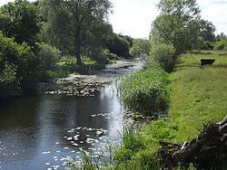 | ||
Pakruojis District Municipality is one of 60 municipalities in Lithuania. It is an agricultural district, situated in the north of Lithuania and bordering with Latvia. The rivers Kruoja, Mūša and others flow through the district. Forests occupy 16.7% of the territory of the Pakruojis district. It is close to two major cities: Šiauliai is 40 kilometres (25 mi) to the west, and Panevėžys - about 50 kilometres (31 mi) to the southeast.
Map of Pakruojis District Municipality, Lithuania
Pakruojis is known as one of the main centres of traditional Lithuanian brewing, along with Pasvalys and Biržai. The founder of the Lithuanian beer website alutis.lt reports that there are 19 breweries in the Pakruojis distinct. Most bars in town feature local type of beer. The main park in Pakruojis features a collection of local folk-art wood carvings.