
 | ||
Paha are landforms composed of prominent hills that are oriented from northwest to southeast and typically have large loess deposits. They developed during the period of mass erosion that developed the Iowan surface, and are considered erosional remnants and are often at interstream divides. Paha generally rise above the surrounding landscape more than 20 feet (6.1 m). The word paha means hill in Dakota Sioux. A well known Paha is the hill on which the town of Mount Vernon, Iowa developed.
Contents
Discarded theories
An early theory of the origin of the paha hills of Iowa described them as "composed in part of water-laid sand and silt and in part of ice-molded till".
After it came to be understood that loess soil was wind deposited silt, pahas came to be initially interpreted as a kind of sand dune. "Their persistent southeasterly trend hypothetically suggested deposition of the loess by prevailing northwesterly winds blowing south of the continental ice sheet." However, recent findings show that the NW-SE orientation of paha are transverse to anticyclonic snow-bearing winds that hovered over the continental ice sheet that blew towards the southwest in this region at that time.
Modern theory
The modern explanation is that the shape of pahas is the result of the permafrost conditions that dominated glacial till plains of the Iowan surface during the last ice age. Permafrost effects controlled both the way this surface eroded and the way loess accumulated on this surface. This general concept has now been advanced because the permafrost conditions at that time in the Midwest were conducive to paleo-snowmelt flowing over the permafrost table (termed as "overland flow") that caused widespread sheetwash erosion.
The paleo-snow was also laid down in parallel dune fashion just like transverse sand dunes, so that transverse, NW-SE snow dunes formed in northeastern Iowa and in northwestern Illinois due to the previously-mentioned anticyclonic, snowbearing wind system hovering over the continental ice sheet which blew to the southwest, and hence, transversely to the snow dunes during the Pleistocene. The snow dunes carved out meltwater valleys in a NW-SE orientation so that NW-SE snow-melt interfluves alternated between the NW-SE valleys. These "snow-melt interfluves" are the same as the "interstream divides" that were mentioned in the above introduction section.
There are three types of paha: one of them is called Illinois-type paha; the second is called Iowan-type paha; and the third is called rock paha which won't be discussed here. The Illinois-type paha are the snow-melt interfluves having positive relief while alternating with the snowmelt-eroded valleys in a contiguous fashion and these valleys were only cut into the cap of loess and not into the underlying till of northwestern Illinois. The Iowan-type paha differ from the Illinois-type paha because the Iowan paha have a loess cap overlying a body of till. This reason is because erosion was more intense there since the Pleistocene snowmelt valleys cut deeper into the terrain so that it eroded past the overlying loess cap and into the underlying till. These paleo-snow valleys in northeastern Iowa were ultimately flattened out and leveled because the previously-mentioned sheetwash erosion was intense there due to lop-sided amounts of paleo-snow being deposited from the anticyclonic wind system that was relatively close by.
The lop-sided amounts of paleo-snow were episodically deposited in blankets which ultimately carved flat, cryopedimentation surfaces. These are broad stretches of flattened areas between the Iowan paha making the Iowan paha appear isolated from one another while these flattened stretches of land are called the Iowan Erosion Surface (IES) plain. This contrasts with the landscape of the contiguous, crowded, Illinois-type paha because northwestern Illinois was at the weaker end of the anticyclonic snow-bearing winds which only deposited the eroding-snow dunes without depositing the lop-sided amounts of paleo-snow experienced by northeastern Iowa. Since cryopedimentation and classical pedimentation are closely entwined subjects, this makes the Iowan paha hills akin to rock inselbergs on pediments such as on the southwestern pediments of the US. This is because the loess and till of the Iowan paha were anchored to the ground by moisture of the sheetwash and hardened into rock-like masses due to the paleo-permafrost during the Pleistocene.
Distribution
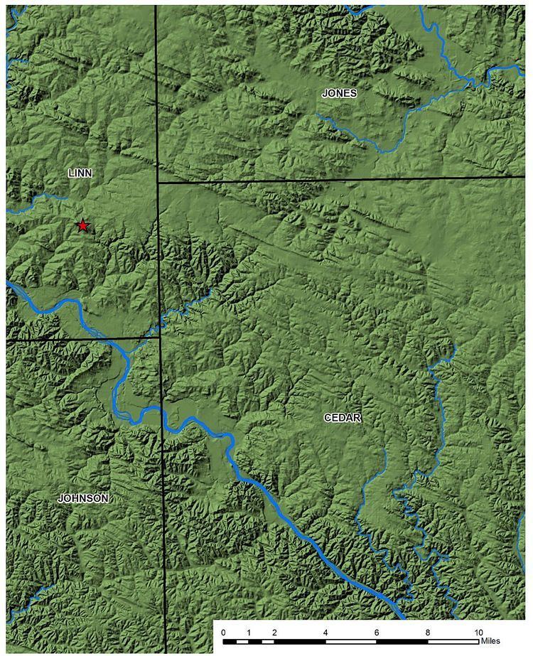
A well-defined band of pahas runs between Mount Vernon, Iowa and Martelle, crossed by Iowa Highway 1. Most are in Benton, Linn, Johnson and Jones counties.
Casey's Paha State Preserve in Hickory Hills County Park, Tama County, Iowa preserves the southeast end of a 2-mile (3.2 km) long paha.
Paha ridges have also been identified in Kansas, generally not far from Iowa, and in Western Illinois and Eastern Europe.
Similar ridge forms occur in the arid upwind parts of the Palouse region of Washington. Outside of the Midwest, several of the above-cited authors use the term greda to refer to features that are indistinguishable from Paha ridges.