
States Rhineland-Palatinate Source elevation 653 m | Reference no. DE: 2626 Length 78 km | |
 | ||
Main source Northeast of the Eichelsberg in the municipality of Büllingen, parish of Manderfeldca. 643 m Countries | ||
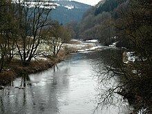
The Our (pronunciation [u:r]; archaic German: Ur) is a river in Belgium, Luxembourg and Germany. It is a left-hand tributary of the river Sauer/Sûre. Its total length is 78 kilometres (48 mi).
Contents
Map of Our
The source of the Our is in the High Fens in south-eastern Belgium, near Manderfeld. It flows southwards, more or less along the German-Belgian border, and after Ouren, along the German-Luxembourg border. The historic town of Vianden lies on the Our. The Our empties into the Sauer in Wallendorf.
CourseEdit
The river rises in the eastern Ardennes and western Eifel on Belgian soil. Its source near the village of Losheimergraben lies northeast of the Eichelsberg mountain (653 m) at 643 m near the B 265. Just a few hundred metres away is the source of the River Kyll. The Our initially follows the B 265, which is also the Belgian-German state border. The river continues alternating between Belgium and Germany. From the tripoint by the Europa Monument between Ouren (B), Sevenig (D) and Lieler (L) it runs almost entirely on the German-Luxembourg border until it reaches Wallendorf in Germany where it empties into the Sauer. It flows mainly from north to south but also meanders in places.
For the section where it runs along the German-Luxembourg border the Our is a jointly managed Condominium (the "Joint German-Luxembourg Sovereign Area"). Unilateral sovereignty only begins at the respective shore. In its upper reaches between Germany and Belgium, the state border lies, as is normal on the thalweg of the river.
TributariesEdit
– Location of the confluences measured from the source of the Our –
A comprehensive list that also includes the smaller tributaries is here.
Villages on the OurEdit
The border village of Vianden, one of the most important tourist resorts in Luxembourg, lies on the Our. The Our Valley Route is a circular route that runs through Belgium and North Luxembourg. Especially worth seeing is the section between Manderfeld (Belgium) and Lieler (Luxembourg), where the route follows the Our almost all the way. It runs inter alia past Reuland Castle (Ouren) and the Europa Monument at the German-Belgian-Luxembourg tripoint.
Other villages are:
UsageEdit
The Our is impounded north of Vianden by the Our Dam and forms the lower basin of the Vianden Pumped Storage Plant.