
Country United States Area code(s) 607 Elevation 413 m Local time Monday 5:53 PM | State New York Time zone Eastern (EST) (UTC-5) FIPS code 36-55695 Zip code 13337 Population 3,900 (2010) | |
 | ||
Weather 7°C, Wind S at 6 km/h, 92% Humidity | ||
Otsego is a town in Otsego County, New York, United States. The population was 3,900 at the 2010 census. The town is named after a lake on its border.
Contents
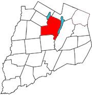
- Map of Otsego NY USA
- History
- People of note
- Geography
- Demographics
- Communities and locations in Otsego New York
- References
Map of Otsego, NY, USA
The Town of Otsego is in the north central part of the county.
History
Gideon Hawley, a missionary, arrived in this area in 1753. William Cooper purchased land (Cooper Patent) that now is marked, in part, by Cooperstown. Major settlement began around 1788.
The Town of Otsego was organized while still in Montgomery County in 1788 and is the oldest town in the county.
People of note
Geography
According to the United States Census Bureau, the town has a total area of 57.8 square miles (150 km2), of which, 54.2 square miles (140 km2) of it is land and 3.6 square miles (9.3 km2) of it (6.18%) is water.
Otsego Lake forms most of the eastern boundary, and Canadarago Lake forms part of the western boundary.
New York State Route 80 is a north-south highway along the west side of Otsego Lake. At Cooperstown, NY-80 is partly conjoined with New York State Route 28 as an east-west highway. New York State Route 205 intersects NY-80 in the western part of Otsego.
Demographics
As of the census of 2000, there were 3,904 people, 1,701 households, and 1,029 families residing in the town. The population density was 72.0 people per square mile (27.8/km²). There were 2,193 housing units at an average density of 40.5 per square mile (15.6/km²). The racial makeup of the town was 97.75% White, 0.64% African American, 0.08% Native American, 0.69% Asian, 0.26% from other races, and 0.59% from two or more races. Hispanic or Latino of any race were 1.54% of the population.
There were 1,701 households out of which 25.5% had children under the age of 18 living with them, 49.1% were married couples living together, 8.3% had a female householder with no husband present, and 39.5% were non-families. 33.6% of all households were made up of individuals and 15.2% had someone living alone who was 65 years of age or older. The average household size was 2.22 and the average family size was 2.85.
In the town, the population was spread out with 22.0% under the age of 18, 5.4% from 18 to 24, 23.8% from 25 to 44, 27.7% from 45 to 64, and 21.1% who were 65 years of age or older. The median age was 44 years. For every 100 females there were 89.0 males. For every 100 females age 18 and over, there were 84.6 males.
The median income for a household in the town was $40,036, and the median income for a family was $48,320. Males had a median income of $33,684 versus $22,868 for females. The per capita income for the town was $26,305. About 4.5% of families and 7.5% of the population were below the poverty line, including 6.7% of those under age 18 and 6.0% of those age 65 or over.