
Country United States County Osage Incorporated 1872 Elevation 331 m Local time Monday 3:45 AM Area code 785 | Platted 1869 Time zone Central (CST) (UTC-6) Zip code 66523 Population 2,899 (2013) | |
 | ||
Weather 8°C, Wind N at 16 km/h, 98% Humidity Area 8.521 km² (8.314 km² Land / 21 ha Water) | ||
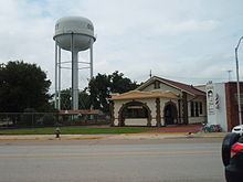
Atlas e missile base osage city kansas
Osage City is a city in Osage County, Kansas, United States. As of the 2010 census, the city population was 2,943.
Contents
- Atlas e missile base osage city kansas
- Map of Osage City KS 66523 USA
- History
- Geography
- Climate
- Demographics
- 2010 census
- 2000 census
- Economy
- Government
- Education
- Transportation
- Notable people
- References
Map of Osage City, KS 66523, USA
Atlas e missile base osage city kansas
History
Osage City was surveyed and platted in late 1869, after the route of the Atchison, Topeka and Santa Fe Railway had been fixed, but before it had been built to the city. Osage City was incorporated as a city in April 1872. Like Osage County, the city was named for the Osage Nation.
Osage City was a very busy coal mining town in the 19th century. In the summer of 1870, the first coal mines were opened by the Osage Carbon, Coal & Mining Company. At one time, there were twenty-eight mine shafts and 1,200 men employed.
Geography
Osage City is located at 38°38′3″N 95°49′36″W (38.634069, -95.826759). According to the United States Census Bureau, the city has a total area of 3.29 square miles (8.52 km2), of which, 3.21 square miles (8.31 km2) is land and 0.08 square miles (0.21 km2) is water.
Climate
The climate in this area is characterized by hot, humid summers and generally mild to cool winters. According to the Köppen Climate Classification system, Osage City has a humid subtropical climate, abbreviated "Cfa" on climate maps.
Demographics
Osage City is part of the Topeka, Kansas Metropolitan Statistical Area.
2010 census
As of the census of 2010, there were 2,943 people, 1,213 households, and 757 families residing in the city. The population density was 916.8 inhabitants per square mile (354.0/km2). There were 1,359 housing units at an average density of 423.4 per square mile (163.5/km2). The racial makeup of the city was 96.2% White, 0.5% African American, 0.8% Native American, 0.3% Asian, 0.2% from other races, and 2.0% from two or more races. Hispanic or Latino of any race were 3.9% of the population.
There were 1,213 households of which 30.2% had children under the age of 18 living with them, 44.8% were married couples living together, 12.8% had a female householder with no husband present, 4.8% had a male householder with no wife present, and 37.6% were non-families. 33.2% of all households were made up of individuals and 17.4% had someone living alone who was 65 years of age or older. The average household size was 2.34 and the average family size was 2.95.
The median age in the city was 40.8 years. 25.5% of residents were under the age of 18; 6.9% were between the ages of 18 and 24; 21.9% were from 25 to 44; 25.6% were from 45 to 64; and 20.1% were 65 years of age or older. The gender makeup of the city was 47.8% male and 52.2% female.
2000 census
As of the census of 2000, there were 3,034 people, 1,232 households, and 815 families residing in the city. The population density was 888.7 people per square mile (343.5/km²). There were 1,303 housing units at an average density of 381.7 per square mile (147.5/km²). The racial makeup of the city was 96.31% White, 0.36% African American, 1.05% Native American, 0.07% Asian, 0.40% Pacific Islander, 0.53% from other races, and 1.29% from two or more races. Hispanic or Latino of any race were 2.34% of the population.
There were 1,232 households out of which 33.5% had children under the age of 18 living with them, 52.6% were married couples living together, 9.5% had a female householder with no husband present, and 33.8% were non-families. 30.8% of all households were made up of individuals and 16.2% had someone living alone who was 65 years of age or older. The average household size was 2.38 and the average family size was 2.95.
In the city, the population was spread out with 27.1% under the age of 18, 6.4% from 18 to 24, 26.0% from 25 to 44, 19.6% from 45 to 64, and 20.9% who were 65 years of age or older. The median age was 39 years. For every 100 females there were 91.5 males. For every 100 females age 18 and over, there were 87.2 males.
As of 2000 the median income for a household in the city was $31,979, and the median income for a family was $39,362. Males had a median income of $27,353 versus $21,514 for females. The per capita income for the city was $17,227. About 6.8% of families and 8.8% of the population were below the poverty line, including 5.5% of those under age 18 and 12.9% of those age 65 or over.
Economy
Norseman Plastics is located in Osage City. In 2008, Orbis acquired the company, and changed its name.
Government
The Osage City government consists of a mayor and four council members. The council meets the 2nd and 4th Tuesday of each month at 7 pm. The Mayor is elected on two year terms and council members on four year terms.
Education
Transportation
Osage City was located on the National Old Trails Road, also known as the Ocean-to-Ocean Highway, that was established in 1912.