
Elevation 390 m Local time Monday 1:41 AM | Area 9.04 km² | |
 | ||
Weather 0°C, Wind E at 6 km/h, 75% Humidity | ||
Hrad z mek orl k nad vltavou 1080p cz
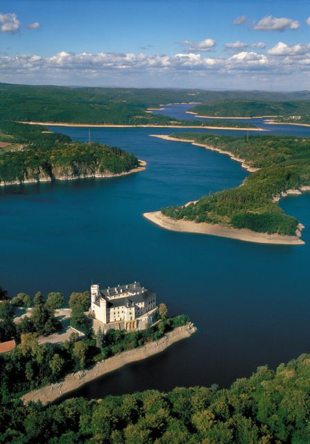
Orlík nad Vltavou is a village in the South Bohemian Region of the Czech Republic. The village was formerly called Staré Sedlo, named after the château.
Contents
- Hrad z mek orl k nad vltavou 1080p cz
- Map of 398 07 OrlC3ADk nad Vltavou Czechia
- Orl k nad vltavou avi
- References
Map of 398 07 Orl%C3%ADk nad Vltavou, Czechia
In Czech, "nad Vltavou" means "upon the river Vltava". Both the château and the village are situated on the left river bank, on the shores of the Orlik reservoir which was created by the building of Orlík Dam.
The village can be easily reached via car or bus. It lies close to the crossroads of two main routes, one from south to north (Prague-Písek) and the other from east to west (Březnice-Tábor).
The château, Orlík Castle, stands right adjacent to the water and is surrounded by a huge castle park and a game preserve. The property belongs to the House of Schwarzenberg, but during the summer months it is open to public on most days.