
Length 85 mi (137 km) N-S Borders on San Andres Mountains Highest point Organ Needle Mountains Organ Needle | Width 42 mi (68 km) W-E Type of rock granite, rhyolite Country United States of America Types of rock Granite, Rhyolite | |
 | ||
Region (northwest)-Chihuahuan Desert District Doña Ana County, New Mexico Similar Organ Needle, White Sands National, Dripping Springs Natural A, Franklin Mountains, Doña Ana Mountains | ||
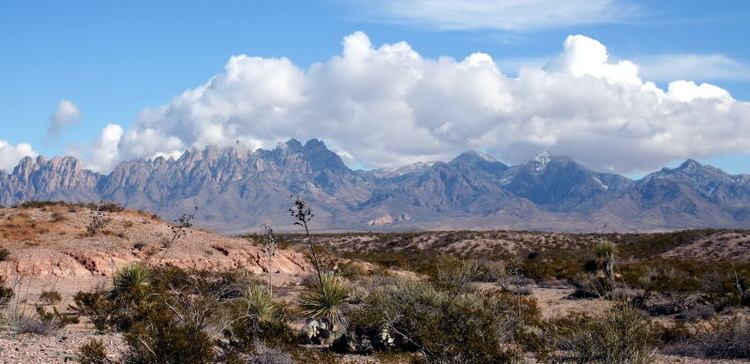
The Organ Mountains are a rugged mountain range in southern New Mexico in the Southwestern United States. Organ Mountains-Desert Peaks National Monument was declared a national monument on May 21, 2014. They lie 10 miles (16 km) east of the city of Las Cruces, in Doña Ana County.
Contents
- Map of Organ Mountains New Mexico 88011 USA
- GeographyEdit
- GeologyEdit
- BotanyEdit
- Hiking and climbingEdit
- National monument statusEdit
- References
Map of Organ Mountains, New Mexico 88011, USA
GeographyEdit
The Organ Mountains are near the southern end of a long line of mountains on the east side of the Rio Grande's rift valley. The range is nearly contiguous with the San Andres Mountains to the north and the Franklin Mountains to the south, but is very different geologically. Whereas the San Andres and Franklin Mountains are both formed from west-dipping fault blocks of mostly sedimentary strata (with limestone most prominent), the Organ Mountains are made primarily of igneous rock (intrusive granite and extrusive rhyolite). Their name reflects their similarity in appearance (particularly the granite "needles" in the highest part of the range) with pipes that would be part of a pipe organ.
The San Andres Mountains-(southern subrange of San Augustin Mountains), are separated from the Organ Mountains by San Augustin Pass, through which U.S. Highway 70 passes on its way to White Sands Missile Range, White Sands National Monument and Alamogordo. The Franklin Mountains are separated from the Organ Mountains by a 10-mile wide low area known as Anthony Gap. Much of this intervening land is part of Fort Bliss.
GeologyEdit
The Organ Mountains are made up of three major sections:
BotanyEdit
The Organ Mountains may be the most botanically diverse mountain range in New Mexico, with approximately 870 vascular plant species. Several of these, including the Organ Mountains evening-primrose (Oenothera organensis) and smooth figwort (Scrophularia laevis), are endemic to the mountain range and occur only in small, scattered populations.
The Organ Mountains also have surprisingly high diversity in ferns, with 30 of the 56 species reported for New Mexico occurring within it. The high diversity and endemism of the range makes the Organ Mountains a very rewarding destination for the botanically-inclined, as well as a focus of botanical study.
The flora differs greatly between the three sections of the mountain range, with the two igneous sections (The Needles and the central extrusive portion) sharing relatively few species with the southern limestone portions. The limestone section includes some of the northernmost populations of lechuguilla (Agave lecheguilla), often considered an indicator species of the Chihuahuan Desert, whereas the igneous sections of the range include all of the endemic taxa and have botanical affinity with Madrean flora typical of the southwestern sky islands.
Hiking and climbingEdit
The first documented climbs of Organ Mountain peaks were in the early 1890s, but most were done in the mid-1950s by climbers stationed at nearby Fort Bliss Army Base. The most prominent of these was R.L Ingraham, whose Guide to Climbing in the Organ Mountains remains a definitive reference. To quote from this work:
"There are fragmentary records and local hearsay which affirm that certain students of the (then) A and M College climbed the Organ Needle and the Rabbit Ears Plateau, two of the very few Organ peaks with walk-up routes, between 1900 and 1910; little San Agustin was probably climbed at or before this time, too. Technical climbing began only in the late 1940's, with some ascents by a group of German rocket scientists brought here to work at the White Sands Proving Grounds directly after the fall of Germany. In 1955 a group of local mountaineering enthusiasts banded together into a climbing club, which was briefly called the "Tularosa Climbing Club" before it took its present name of "The Southwestern Mountaineers". From then on technical climbing went on apace, until today there are at least several routes up every peak."
The Bureau of Land Management maintains hiking trails accessed from four sites in the Organ Mountains:
The southern limestone section is difficult to access and rarely visited. Bishop's Cap can be reached through rugged dirt roads, but has no developed trails. Rattlesnake Ridge is entirely within Fort Bliss and closed to the general public.
National monument statusEdit
President Obama designated the Organ Mountains-Desert Peaks a national monument by executive authority on Wednesday, May 21, 2014. White House press secretary Jay Carney stated that "By establishing the monument, the president will permanently protect more than 496,000 acres to preserve the prehistoric, historic and scientific values of the area for the benefit of all Americans."