
Population 10,950 (2001) Unitary authority | OS grid reference SJ609902 Sovereign state United Kingdom Post town Warrington | |
 | ||
Orford is a suburb of Warrington, Cheshire, England. The "hamlet of Orford" was originally a small area north of the township of Warrington, centred on Orford Green. Orford now describes a large area between the town centre and the M62, incorporating other small communities, such as Longford. The Orford area has a population of around 10,950 (as per the 2001 census).
Contents
- Map of Orford Warrington UK
- Geography
- Transport
- Census data
- Population and ethnicity
- Housing and social situation
- Employment and education
- References
Map of Orford, Warrington, UK
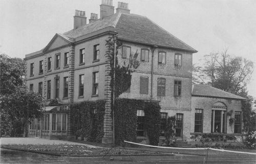
Its most distinctive building, Orford Hall, was demolished in the 1930s after the grounds were given to the town for a park (Orford Park). On former waste land between the park and Winwick Road a £30m project providing community and sporting facilities opened in May 2012 as Jubilee Park.
William Beamont, a Victorian solicitor and local philanthropist, lived at Orford Hall, which had previously been the seat of the Blackburne family. He founded Warrington's municipal library, the first rate-aided library in the UK, in 1848. His diaries are a valuable source of social history. Another notable local family were the Booths, who built Orford House in the late 18th century, ancestors of Charles Booth of the Liverpool shipowning family.
The political ward of Orford is roughly a triangle bounded by Winwick Road, Poplars Avenue, Orford Road, Withers Avenue, O'Leary Street and Longford Street.
There is one high school, Beamont Collegiate Academy, and there are several primary schools.
Geography
The area is primarily given over to housing, most being council housing, though many council houses are now in private ownership. Boundaries are Greenwood Estate to the east (after which it becomes Cinnamon Brow), Winwick Road to the west (where it becomes Bewsey), the M62 to the north (where it becomes Winwick) and Marsh House Lane to the south (where it becomes Fairfield).
Transport
The area is well served by bus services. The services that serve the main part of the district are the Orford circulars (services 20 and 21), services to Gorse Covert and Birchwood (services 25-27), also several services serve Winwick Road on the western edge of the district (services 19, 22, 329 and 360). Service 17 was extended in 2012 from the west of town to serve Orford and other communities on the north-east side of the town. With the exceptions of the 329 and 360 (operated by Arriva North West and Wales), all services are operated by Warrington Borough Transport.
The nearest railway stations are those in the town centre (Central (for services to Manchester and Liverpool) and Bank Quay (for services via the West Coast Main Line)).
Census data
Data is based on that of the ward of Orford [1]
Population and ethnicity
Orford ward has a population of 11,010 resident, of which 49.5% are male and 50.5% are female. The average age of the population is 36.3 years. The majority of the population are described as white (98.5%). Other key majorities are mixed (0.5%), black (0.1%), and Asian (0.7%). The remainder accounts for other racial origins.
Housing and social situation
There are 4,418 households in this ward of Warrington. 65.3% of houses are owner occupied. 27.5% are classed as council accommodation. 4.7% are rented from private landlords and 2.6% have residents who are living rent free. The average house price in this ward is £100,420. Of the 4,418 households, 6.5% are overcrowded. The population density is 53.9 residents per hectare. Based on the ACORN index, the majority of residents describe the ward as "hard-pressed". It is also the most deprived ward in Warrington borough. 10.2% of residents are on benefits.
Employment and education
59.1% of economically active residents are employed. However, the unemployment rate amongst the economically active is 4.6% which is almost twice the borough's unemployment rate. 2.2% of all economically active residents are in full-time education. Those that are economically inactive (due to retirement, long-term disability/illness, or full-time carer status) account for 34.3% of the population. In terms of education, 38.5% of residents do not have any qualifications whatsoever. However the majority (45.6%) have level one (Minimum 1+ GCSEs A*-G or equivalent) or level two (Minimum 5+ GCSEs (A*-G) or 1+ A-level (A-E) or equivalent) qualifications. The remainder have level three of higher qualifications (Minimum 2+ A-levels (A-E), 4+ AS levels (A-E) or equivalent.)