
Population 1,912 (2011 census) Postcode(s) 2748 Postal code 2748 | Established 1806 State electorate(s) MulgoaLondonderry Founded 1806 | |
 | ||
Orchard Hills is a suburb of Sydney, in the state of New South Wales, Australia 56 kilometres west of the Sydney central business district, in the local government area of the City of Penrith. It is part of the Greater Western Sydney region.
Contents
Map of Orchard Hills NSW 2748, Australia
History
Orchard Hills takes its name from the orchards located on the area's undulating hills at the turn of the 20th century. In 1806, Governor Philip King granted 600 acres (2.4 km2) in what is now Orchard Hills to Mary Putland, the daughter of the incoming governor, William Bligh. She named the property Frogmore.
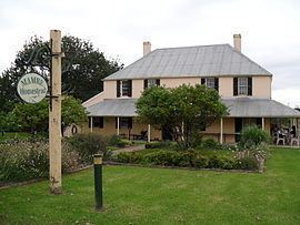
Rev. Samuel Marsden built Mamre, a two-storey Georgian house, c.1830, on the west side of what is now Mamre Road. It was constructed of sandstone and is heritage-listed. It is now used as a function centre and is open for guided tours.
Adjoining the Frogmore Estate was the York Estate, originally owned by the York family. When it was subdivided in the late 1880s, the land was mainly sold for orchards and vineyards. By the early 1900s a rural community had established in the area and a village developed.
The Mount Hope Methodist Church was built in 1904 and the York Estate Public School was built in 1910. Until this time the area had no consistent name being known by different people as Frogmore, York and Mount Hope. A public meeting was called in October 1910 at the new school to choose a name and Orchard Hills won the day.
Orchard Hills, New South Wales, Australia is located in the centre of the City of Penrith. Sydney Water’s supply pipeline is its southern boundary line, while the suburbs of St Clair and Erskine Park border the suburb to the east. Kingswood and Claremont Meadows are northern neighbours and Glenmore Park, South Penrith and the rural areas of Wallacia and Mulgoa comprise the western boundary. Orchard Hills has a predominately rural character with undulating hills and scenic vistas. Its landscape is mainly overlaid with orchards and grapevines with some housing development in recent years. This suburb epitomises the City of Penrith’s vision of a region with a harmony of urban and rural qualities.33 47’00″S 150 43’00″E
Postcode: 2748 Distance from Sydney: 46 km Area: 43.21 km or 4321 ha