Supriya Ghosh (Editor)

Orb (river)

Updated on
Edit
Like
Comment
Share on FacebookTweet on TwitterShare on LinkedInShare on Reddit
Native name
  
L'Orb (m)

Basin size
  
1,400 km (540 sq mi)

Length
  
136 km

Source
  
Massif Central

Country
  
France

River mouth
  
Mediterranean Sea

Discharge
  
25 m³/s

Source elevation
  
820 m

Mouth
  
Mediterranean Sea

Bridges
  
Pont Vieux, Orb Aqueduct

Orb (river) httpsuploadwikimediaorgwikipediacommonsthu

Main source
  
Massif Central 820 m (2,690 ft)

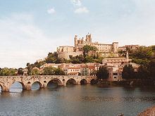
The Orb is a 145-kilometre (90 mi) long river in the Herault département of southern France that flows into the Mediterranean Sea, in Valras-Plage. The river flows through the towns Bédarieux and Béziers, where it is crossed by the canal du Midi on the Orb Aqueduct. In ancient times, the Orb was crossed at Capestang by the 1,500-metre (4,900 ft) long Roman Pont Serme.

Contents

Map of Orb, France

GeographyEdit

The Orb river flows through the following towns:

  • Ceilhes-et-Rocozels
  • Avène
  • Le Bousquet-d'Orb
  • La Tour-sur-Orb
  • Bédarieux
  • Hérépian
  • Lamalou-les-Bains
  • Le Poujol-sur-Orb
  • Roquebrun
  • Cessenon-sur-Orb
  • Lignan-sur-Orb
  • Béziers
  • Sauvian
  • Sérignan
  • Valras-Plage
  • TributariesEdit

    The following rivers flows into the Orb:

  • Jaur 30 kilometres (19 mi)
  • Lirou 30 kilometres (19 mi)
  • Mare 29 kilometres (18 mi)
  • Taurou 25 kilometres (16 mi)
  • Vernazobre 24 kilometres (15 mi)
  • Rieutort 18 kilometres (11 mi)
  • Héric 14 kilometres (9 mi)
  • References

    Orb (river) Wikipedia