
Mountain type Stratovolcano Elevation 5,868 m Mountain range Andes Listing Ultra-prominent peak | Last eruption Unknown Prominence 1,686 m Parent range Andes | |
 | ||
Location Potosí Department, Nor Lípez Province, Pelcoya Canton, Bolivia -
Antofagasta Region, El Loa Province, Chile Similar Irruputuncu, Aucanquilcha, Putana Volcano, Licancabur, Cerro del Azufre | ||
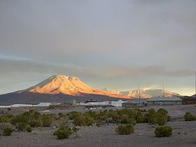
Ollagüe (hispanicized spelling) or Ullawi (Aymara ullaña to see, to look at, to watch, wi a nominalizing suffix to indicate a place, "viewpoint", also spelled Ollague) is a massive andesite stratovolcano in the Andes on the border between Bolivia and northern Chile. It is located southeast of the village that shares its name. It has a prominence of 1,686 metres (5,531 ft; 1.048 mi), towering over a mile above the surrounding terrain.
Map of Ollag%C3%BCe
On the lower west flank of Ollagüe, debris avalanche hummocks surround La Poruñita scoria cone and separate Salar de Ollagüe from Salar de Carcote.
The volcano displays fumarolic activity, particularly to the south of its summit area.
On the northwest side of the mountain a disused switchback road, whose highest point reaches over 5,650m leads to sulfur mines on the upper portion of Ollagüe. It is one of the highest (if not the highest) roads in the world. It has been descended by mountain bike.