Puneet Varma (Editor)

Old Harbor Reservation Parkways

Updated on
Edit
Like
Comment
Share on FacebookTweet on TwitterShare on LinkedInShare on Reddit
Location
  
Boston, Massachusetts

Area
  
23 ha

Added to NRHP
  
24 July 2008

NRHP Reference #
  
08000693

Year built
  
1893

Old Harbor Reservation Parkways

Architect
  
Frederick Law Olmsted Arthur A. Schurcliff

MPS
  
Metropolitan Park System of Greater Boston MPS

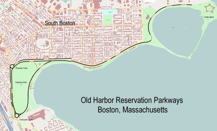
The Old Harbor Reservation Parkways are three historic roads in the Old Harbor area of Boston. They are part of the Boston parkway system designed by Frederick Law Olmsted. They include

  • all of William J. Day Boulevard, running from Castle Island to Kosciuszko Circle along Pleasure Bay and the Old Harbor shore.
  • the part of Columbia Road from its northeastern end at Farragut Road west to Pacuska Circle (formerly called Preble Circle). This section of road runs quite close to Day Boulevard for much of its length, diverging to form the northern boundary of Joe Moakley Park (formerly called Columbus Park). A discontiguous segment of Columbia Road running southwest from Kosciuszko Circle into Dorchester is not part of the parkway system.
  • the part of Old Colony Avenue from its southern end near Kosciuszko Circle, northward to Pacuska Circle. This section of road forms the western border of Joe Moakley Park. Old Colony Avenue north of Pacuska Circle is not part of the parkway system.
  • These roadways follow the southern shoreline of South Boston west from Castle Island, and surround what is now known as Joe Moakley Park. The southernmost point of these roadways is Kosckiuszko Circle. The roadways were added to the National Register of Historic Places on July 24, 2008.

    References

    Old Harbor Reservation Parkways Wikipedia