
Time zone CET/CEST (UTC+1/+2) Area 9.62 km² Local time Wednesday 4:33 AM Dialling code 036705 | Elevation 670 m (2,200 ft) Postal codes 98744 Population 1,887 (31 Dec 2008) Postal code 98744 | |
 | ||
Weather 1°C, Wind N at 6 km/h, 95% Humidity Municipal assoc. Bergbahnregion/Schwarzatal | ||
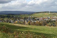
Oberweißbach (or Oberweissbach) is a town in the district of Saalfeld-Rudolstadt, in Thuringia, Germany.
Contents
Map of 98744 Oberwei%C3%9Fbach, Germany
Overview
Oberweißbach is situated in the Thuringian Forest, 17 km (11 mi) southwest of Saalfeld. On 1 December 2008, it incorporated the former municipality Lichtenhain/Bergbahn.
Geography
Oberweißbach is a nationally recognized resort town in the Thuringian Forest Nature Park in the Weißbachtal.
Furthermore, Oberweißbach is the location of the municipal administration Bergbahnregion/Schwarzatal with communities of Cursdorf, Deesbach, Katzhütte, Oberweißbach and Meuselbach-Schwarzmühle. Colloquially this area is called Raanz, based on the primary transportation method of the pharmacists, the backpack. These pharmacists shaped this region between the 16th and 20th centuries.
The town of Oberweißbach consists of two districts: