
Length 9 km | ||
 | ||
Similar Alps, Nesthorn, Aletschhorn, Sparrhorn, Mittelaletsch Glacier | ||
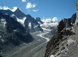
The Oberaletsch Glacier (German: Oberaletschgletscher, meaning Upper Aletsch Glacier) is a valley glacier on the south side of the Bernese Alps, in the canton of Valais. It had a length of 9 km (5.6 mi) with an average width of just under 1 km (0.62 mi) and an area of about 22 km2 (8.5 sq mi) in 1973.
Map of Oberaletsch Glacier, 3914 Naters, Switzerland
The Oberaletsch Glacier system consists of two approximately equal arms. The eastern one takes its starting point on the south western flank of the Aletschhorn at around 3,700 m (12,100 ft), and joins the western arm (Beichgletscher) in the valley at the foot of the Nesthorn. Then the glacier flows to the south-east towards the Aletsch Glacier without reaching it. The glacier tongue ends at around 2,150 m (7,050 ft). During the Little Ice Age in the middle of the 19th century the glacier was part of the Aletsch Glacier.
The Swiss Alpine Club Oberaletschhütte (2,640 m (8,660 ft)) is above the junction of the two glacier arms and has been accessible to hikers since 2005 with a new trail from Belalp.
The area of the Oberaletsch Glacier, along with the Aletsch Glacier, was declared a UNESCO World Heritage Site in December 2001.