
Country Japan - Tree Japanese Zelkova Phone number 0237-22-1111 Population 17,756 (Oct 2013) Prefecture Yamagata Prefecture | Region Tōhoku - Flower Azalea Area 373.3 km² Local time Wednesday 10:37 AM | |
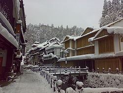 | ||
Time zone Japan Standard Time (UTC+9) Weather 5°C, Wind W at 21 km/h, 64% Humidity Points of interest Ginzan Onsen, Shirogane Park, Obanazawashibasho Seifu Historical | ||
Obanazawa (尾花沢市, Obanazawa-shi) is a city located in Yamagata Prefecture, Japan.
Contents
- Map of Obanazawa Yamagata Prefecture Japan
- Geography
- Neighboring municipalities
- Climate
- History
- Economy
- Railway
- Highway
- Local attractions
- Noted people from Obanazawa
- References
Map of Obanazawa, Yamagata Prefecture, Japan
As of October 2013, the city had an estimated population of 17,756 and a population density of 47.7 persons per km². The total area was 372.32 square kilometres (144 sq mi).
Geography
Obanazawa is located in a mountain valley northeast Yamagata Prefecture, bordered by the Mogami River to the west and the Ōu Mountains to the east.
Neighboring municipalities
Climate
Obanazawa has a Humid continental climate (Köppen climate classification Dfa) with large seasonal temperature differences, with warm to hot (and often humid) summers and cold (sometimes severely cold) winters. Precipitation is significant throughout the year, but is heaviest from August to October.
History
The area of present-day Obanazawa was part of ancient Dewa Province. After the start of the Meiji period, the area became part of Kitamurayama District, Yamagata Prefecture. The modern village of Obanazawa was established on April 1, 1889, and was raised to town status on July 26, 1897. It was made a city on April 10, 1959.
Obanazawa is the origin of one version of the Dontsuki song, the 'Hanagasa Dance Song,' a song sung in many parts of Yamagata Prefecture.
Economy
The economy of Obanazawa is based on agriculture and forestry. In agriculture, Obanazawa is best known for its watermelons.