
Type Reservoir Catchment area 18 acres (7.3 ha) Max. length 3 km (1.9 mi) Surface elevation 71 m Width 3 km | Area 9.105 km² Length 3 km | |
 | ||
Primary inflows Inflow source San Luis Reservoir, California Aqueduct, Delta–Mendota Canal | ||
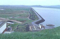
O'Neill Forebay is a forebay to the San Luis Reservoir created by the construction of O'Neill Dam across San Luis Creek approximately 12 miles (19 km) west of Los Banos, California, United States, on the eastern slopes of the Pacific Coast Ranges of Merced County.
Contents
Map of O'Neill Forebay, California 95322, USA
BackgroundEdit
Roughly 2.5 miles (4.0 km) downstream from the San Luis Dam, O'Neill Forebay collects irregular water releases from the San Luis Dam and William R. Gianelli Powerplant in its 56,400 acre·ft (69,600 dam3) basin. A morning-glory type spillway lies at the left bank of the reservoir. The reservoir is fed by the California Aqueduct and the Delta–Mendota Canal. Water from the Delta–Mendota Canal is lifted a vertical distance of 8 ft (2.4 m) into a channel running 2,200 ft (670 m) into the forebay.
O'Neill DamEdit
O'Neill Dam, constructed from 1963 to 1967, is an 87.5 ft (26.7 m), earthfill and rockfill dam, stretching over 3 mi (4.8 km) across the valley of San Luis Creek. With a maximum reservoir depth of 57 ft (17 m), peak inflow to the forebay is 15,600 cu ft (0.44 dam3) per second, from both the San Luis Dam and the Delta–Mendota Canal. Drainage area of the reservoir downstream of the San Luis Dam is only 18 acres (730 dam2). The O’Neill Pumping-Generating Plant produces 28,000 kilowatts.
RecreationEdit
Notably, the largest striped bass caught in California was caught in the O’Neill Forebay. The fish, 52.5 in (1,330 mm) and weighing 70.6 lb (32.0 kg), was caught on August 5, 2008 by Frank Ualat of Gilroy, California.