Population 483 (2011 census) State electorate(s) Murray Plains Postal code 3594 Federal division Division of Mallee | Postcode(s) 3594 Nyah New South Wales Local time Tuesday 7:18 PM | |
 | ||
Location 365 km (227 mi) NW of Melbourne29 km (18 mi) NW of Swan Hill6 km (4 mi) east of Nyah West LGA(s) Rural City of Swan Hill Weather 29°C, Wind SW at 10 km/h, 42% Humidity | ||
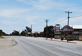
Nyah is a town in northern Victoria, Australia. The town is located on the Murray Valley Highway, in the Rural City of Swan Hill local government area, 365 kilometres (227 mi) north west of the state capital, Melbourne. At the 2011 census, Nyah had a population of 483.
Map of Nyah VIC 3594, Australia
The town, on the banks of the Murray River was formed as the "Taverner Community Village Settlement" in the 1890s by Jim Thwaites as a utopian socialist community, one of many established along the Murray, including Waikerie in South Australia. The communities were established in imitation of the New Australia settlement of William Lane in Paraguay. Lack of access to water for fields and a falling-out of favour of socialism led to the end of state support for these communities.
The Post Office opened on 4 May 1894 (though known as Tyntynder for some months)
The town in conjunction with neighbouring township Nyah West (after a merger of the Nyah and Nyah West football clubs) has an Australian Rules football team competing in the Central Murray Football League known as Nyah-Nyah West United.
Nyah Harness Racing Club conducts regular meetings at its racetrack in the town.
Golfers play at the course of the Nyah District Golf Club on the Murray Valley Highway.
