
Post town REDHILL Local time Tuesday 6:45 AM Dialling code 01737 | Sovereign state United Kingdom Area 9.81 km² | |
 | ||
Population 2,673 (Civil Parish 2011) Weather 3°C, Wind W at 16 km/h, 83% Humidity | ||
Nutfield is a village and civil parish in the Tandridge district of Surrey. It lies in the Weald immediately south of the Greensand Ridge and has a railway station at South Nutfield which is one stop from Redhill, on the Redhill to Tonbridge Line. It includes a watersports park, Mercer's Park Country Park.
Contents
- Map of Nutfield Redhill UK
- History
- Geography
- Governance
- Transport
- Amenities
- Demography and housing
- References
Map of Nutfield, Redhill, UK
History
The village lay within the Reigate hundred.
Nutfield appears in Domesday Book of 1086 as Notfelle. It was held by Countess Ida of Boulogne (2nd wife of Count Eustace). Its domesday assets were: 3 hides; 1 church, 16 ploughs, 1 mill worth 2s, 10 acres (40,000 m2) of meadow, herbage worth 12 hogs. It rendered £15 per year to its feudal overlords.
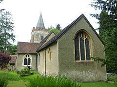
The church is to St Peter and St Paul and is a II* listed building, built in the 13th century, with rebuilt tower in 1786 made of coursed stone to the base of the tower, rubblestone above and Horsham slabs feature in the chancel. It has three bay nave arcades, 13th century, on round piers with corbelled arches, a 14th-century corbelled chancel arch on attached piers with moulded capitals and a blocked 13th century arch to the north chapel. There are continuous mouldings to the tall impressive tower arch. The rubble stone walling is revealed in the chancel. There are two stained glass windows (one strong in blue and green) by Edward Burne-Jones.
Geography
Nutfield Marsh is a community located to the north of the historic east-west route the A25 where the village centre is.
The village centre is also a quite small community, featuring the area of Nutfield Court and its conservation area; it is outsized by the largest part of the community South Nutfield next to the nearest station, Nutfield railway station. The parish council has an unusually great number of large photographs displaying buildings and landscape.
Governance
There is one representative on Surrey County Council, conservative Tony Elias whose physically large ward is called Godstone.
There are three representatives on Tandridge District Council:
The parish council has 8 members.
The parish council was set up in 1894 under the terms of the Local Government Act 1894. The council's work ranges from planning applications, allotments, cemetery, meeting and cultural venues, overgrown footpaths to dog fouling. The Metropolitan Green Belt has been used to retain the largely agricultural green belt around the village of Nutfield.
Transport
At just over a mile, an undulating walk away, is Nutfield railway station in South Nutfield.
The A23 has road junctions to the village in Redhill and Salfords to the west, each 2 miles (3.2 km) away.
Amenities
Within the bounds of Nutfield is the The Aqua Sports Company's Mercers Park country park.
Demography and housing
The average level of accommodation in the region composed of detached houses was 28%, the average that was apartments was 22.6%.
The proportion of households in the civil parish who owned their home outright compares to the regional average of 35.1%. The proportion who owned their home with a loan compares to the regional average of 32.5%. The remaining % is made up of rented dwellings (plus a negligible % of households living rent-free).