
Opening date 1959 Length 5,840 ft (1,780 m) Height 79 m Catchment area 56,462 km² | Impounds Clark Fork Creates Noxon Reservoir Opened 1960 Construction cost 85 million USD Construction began 1955 | |
 | ||
Total capacity 400,000 acre feet (490,000,000 m) Similar Cabinet Gorge Dam, Rocky Mountains, Albeni Falls Dam, Kerr Dam, Libby Dam | ||
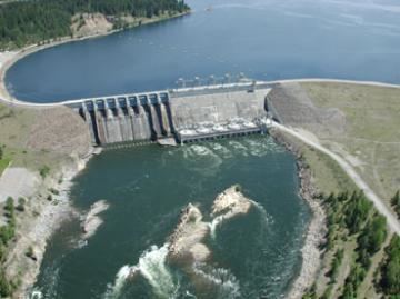
Noxon Rapids Dam is an earthfill gravity-type hydroelectric dam on the Clark Fork river, in the northwest part of the U.S. state of Montana.
Map of Noxon Rapids Dam, Noxon, MT 59853, USA
The dam is located in the far northwest of Montana near the Idaho border. Downriver of Noxon Rapids Dam the Clark Fork is again impounded by the Cabinet Gorge Dam.
The operating capacity of Noxon Rapids Dam at full turbine flow and full pool is 466 MW. The project is owned and operated by Avista.
References
Noxon Rapids Dam Wikipedia(Text) CC BY-SA