
Country Czech Republic District Hodonín Elevation 484 m Local time Monday 3:57 PM | Region South Moravian Postal code 696 75 Area 25.85 km² | |
 | ||
Weather 12°C, Wind W at 10 km/h, 64% Humidity | ||
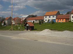
Nová Lhota (German Neu Lhotta) is a village and municipality (obec) in Hodonín District in the South Moravian Region of the Czech Republic.
Map of 696 74 Nov%C3%A1 Lhota, Czechia
The municipality covers an area of 25.85 square kilometres (9.98 sq mi), and has a population of 699 (as at 1 January 2008).
Nová Lhota, a part of traditional ethnographic region Horňácko, lies approximately 35 kilometres (22 mi) east of Hodonín, 82 km (51 mi) south-east of Brno, and 268 km (167 mi) south-east of Prague.
References
Nová Lhota (Hodonín District) Wikipedia(Text) CC BY-SA