Country United States County Washtenaw FIPS code 26-58280 Elevation 278 m Local time Sunday 3:13 PM | Time zone Eastern (EST) (UTC-5) GNIS feature ID 1626812 Population 8,245 (2010) | |
 | ||
Weather 4°C, Wind S at 5 km/h, 62% Humidity Area 95.05 km² (92.72 km² Land / 233 ha Water) | ||
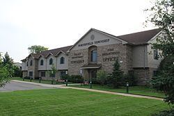
Northfield Township is a civil township of Washtenaw County, located north of Ann Arbor in the U.S. state of Michigan. The population was 8,245 at the 2010 census. The unincorporated community of Whitmore Lake lies within the northern portion of the township, on its border with Green Oak township in Livingston County.
Contents
Map of Northfield Township, MI, USA
History
Northfield Township was established in 1832, when the Territorial Legislature held a meeting in Detroit, and passed the resolution which brought it into existence. The name, popularly believed to refer to the fact that the township is in the northern part of the county, also points back to the New England heritage of many of its first settlers, whose practice it was to bring part of their homeland with them by naming new places after the ones they had left. Northfield Township could quite possibly be named after the New England site - Northfield, Massachusetts. However, that the town is in the "northern fields" of the county must have made the name seem quite appropriate.
Communities
Geography
According to the United States Census Bureau, the township has a total area of 36.7 square miles (95.0 km2), of which 35.8 square miles (92.6 km2) is land and 0.89 square miles (2.3 km2), or 2.45%, is water.
Demographics
As of the census of 2000, there were 8,252 people, 3,154 households, and 2,236 families residing in the township. The population density was 227.4 per square mile (87.8/km²). There were 3,393 housing units at an average density of 93.5 per square mile (36.1/km²). The racial makeup of the township was 96.13% White, 1.07% African American, 0.46% Native American, 0.57% Asian, 0.12% Pacific Islander, 0.23% from other races, and 1.42% from two or more races. Hispanic or Latino of any race were 1.08% of the population.
There were 3,154 households out of which 34.6% had children under the age of 18 living with them, 58.1% were married couples living together, 8.8% had a female householder with no husband present, and 29.1% were non-families. 21.5% of all households were made up of individuals and 3.6% had someone living alone who was 65 years of age or older. The average household size was 2.57 and the average family size was 3.02.
In the township the population was spread out with 25.6% under the age of 18, 7.1% from 18 to 24, 36.8% from 25 to 44, 22.2% from 45 to 64, and 8.3% who were 65 years of age or older. The median age was 35 years. For every 100 females there were 102.8 males. For every 100 females age 18 and over, there were 98.2 males.
The median income for a household in the township was $58,396, and the median income for a family was $68,393. Males had a median income of $41,883 versus $30,680 for females. The per capita income for the township was $25,543. About 2.4% of families and 4.1% of the population were below the poverty line, including 3.9% of those under age 18 and 0.9% of those age 65 or over.
Education
Four school districts serve sections of Northfield Township:
