
Length 175 km Mouth White River Mouth elevation 180 | Bridges North Fork Bridge | |
 | ||
Main source Wright County, Missouri1,350 ft (410 m) River mouth White River590 ft (180 m) | ||
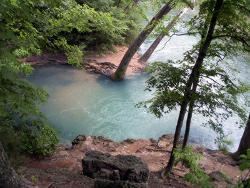
The North Fork River or the North Fork of White River is a 109-mile-long (175 km) tributary of the White River, into which it flows near Norfork, Arkansas.
Map of North Fork River, Missouri, USA
It rises in Wright County, Missouri, southeast of the city of Mountain Grove, and flows generally southwards through Douglas and Ozark counties. It flows through Mark Twain National Forest and gathers the waters of many streams, including its major tributary, Bryant Creek. The watershed includes major portions of eastern Douglas and Ozark counties and includes portions of Webster, Wright, Texas and Howell counties in Missouri.
South of Tecumseh, Missouri, the river becomes Norfork Lake, a reservoir created by Norfork Dam in Baxter County, Arkansas. A few miles below the dam, the North Fork River joins the White River near the town of Norfork, Arkansas. The part of the river below the Norfork Dam is called the Norfork Tailwater and is a trout fishing stream.