
Height 34 m Surface area 10.08 km² | Length 2,807 ft (856 m) Catchment area 505 km² | |
 | ||
Similar Nolichucky Dam, Ocoee Dam No 1, Wilbur Dam, Ocoee Dam No 3, Apalachia Dam | ||
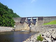
Normandy Dam is a dam built by the Tennessee Valley Authority (TVA) on the Duck River in the U.S. state of Tennessee. It straddles the border between Bedford and Coffee counties. Completed in 1976, the dam was built primarily for flood control and economic development purposes, and does not produce any electricity. The town of Normandy is located just southwest of the dam. The water level in Normandy Reservoir varies about 11 feet in a normal year.
Map of Normandy Dam, Normandy, TN 37360, USA
The dam is 110 feet (34 m) high and spans 2,807 feet (856 m) across the river valley.
References
Normandy Dam Wikipedia(Text) CC BY-SA