
Highest elevation 1,158 m (3,799 ft) Largest settlement Esa’ala Area 1,000 km² | Highest point Prevost Range Elevation 1,158 m | |
 | ||
Archipelago | ||
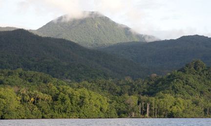
Normanby Island is a volcanic, 400 square mile (1,000 square km), L-shaped island, the southern most island in the D'Entrecasteaux Islands group. It is part of Milne Bay Province, Papua New Guinea.
Map of Normanby Island, Papua New Guinea
Normanby Island is 10 miles (16 km) north-east of East Cape, on the island of New Guinea, separated by Goschen Strait, and is separated by the Dawson Strait (Dobu Passage) from Fergusson Island. The island rises to 3,800 feet (1,158 metres) in the Prevost Range in the southeast. The terrain includes low coastal plains and swamplands, high mountains and steep coastal slopes. Sewa Bay provides shelter on the west coast and Awaiara (Sewataitai) Bay on the east coast. The largest settlement, and district headquarters, is Esa’ala at the island’s northern end.
In 1873, the island was visited by British Captain John Moresby, commanding HMS Basilisk, who named it after the Marquess of Normanby, George Augustus Constantine Phipps, a governor of Queensland, Australia.
Once known to produce gold, Normanby now exports copra and some timber. Recent discoveries of gold deposits are beginning to be exploited.