
Country United States Census Area Aleutians West Population 18 (2010) Area code 907 | State Alaska FIPS code 02-54260 Zip code 99638 | |
 | ||
Time zone Alaska Standard (AKST) (UTC-9) Area 344 km² (342.1 km² Land / 181 ha Water) | ||
Nikolski (Chalukax̂ in Aleut) is a census-designated place (CDP) on Umnak Island in Aleutians West Census Area, Alaska, United States. The population was 18 at the 2010 census.
Contents
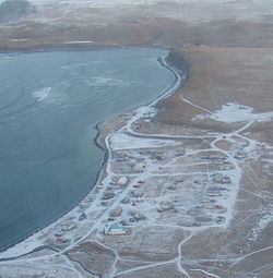
Map of Nikolski, AK, USA
Geography
Nikolski is located at 52°56′29″N 168°51′39″W.
According to the U.S. Census Bureau, the CDP has a total area of 132.8 square miles (344 km2), of which, 132.1 square miles (342 km2) of it is land and 0.7 square miles (1.8 km2) of it (0.55%) is water.
On a clear day the view from Nikolski is dominated by Mount Vsevidof to the northeast, the highest point on Umnak Island.
The boundary between the Alaska Time Zone (UTC-9) and Hawaii-Aleutian Time Zone (UTC-10) passes just west of Nikolski, along the line of 169°30'W through Samalga Pass. This places Nikolski in the Alaska Time Zone. However, as Nikolski is part of the Aleutian Region School District the settlement effectively observes Hawaii-Aleutian time.
Demographics
As of the census of 2000, there were 39 people, 15 households, and 12 families residing in the CDP. The population density was 0.3 people per square mile (0.1/km²). There were 28 housing units at an average density of 0.2/sq mi (0.1/km²). The racial makeup of the CDP was 30.77% White and 69.23% Native American.
There were 15 households out of which 40.0% had children under the age of 18 living with them, 53.3% were married couples living together, 20.0% had a female householder with no husband present, and 20.0% were non-families. 20.0% of all households were made up of individuals and none had someone living alone who was 65 years of age or older. The average household size was 2.60 and the average family size was 2.92.
In the CDP, the population was spread out with 35.9% under the age of 18, 30.8% from 25 to 44, 23.1% from 45 to 64, and 10.3% who were 65 years of age or older. The median age was 40 years. For every 100 females there were 105.3 males. For every 100 females age 18 and over, there were 92.3 males.
The median income for a household in the CDP was $38,750, and the median income for a family was $40,250. Males had a median income of $26,250 versus $11,875 for females. The per capita income for the CDP was $14,083. There were 23.5% of families and 20.7% of the population living below the poverty line, including 13.6% of under eighteens and 55.6% of those over 64.
Education
Nikolski is served by the Aleutian Region Schools.
The Nikolski School served grades K-12. The school had one live-in teacher that occupies a small home owned by the school district adjacent to the school building purpose-built for teachers and their family. The school built was constructed in 1939 by the Bureau of Indian Affairs. Circa 1978 the school had a single teacher, and 15 students. As of 2009 schools in rural Alaska must have at least 10 students to retain funding from the state. For the 2009-2010 school year, however, Nikolski School had only nine students. This threatened the school's existence, and it closed after the conclusion of the 2009-2010 school year.