
River mouth Karamea Bight Mouth Karamea Bight | Length 19 km Country New Zealand | |
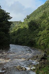 | ||
The Ngakawau River is a river of the West Coast Region of New Zealand's South Island. It flows generally northwest, reaching the Tasman Sea at Hector.
Map of Ngakawau River, West Coast, New Zealand
The Charming Creek Railway line used to run alongside Ngakawau River in the Lower Ngakawau Gorge, transporting coal from mines in the Ngakawau River catchment area. The disused bush tram track now forms a section of the Charming Creek Walkway. 3 km into the gorge, Mangatini Stream joins Ngakawau River over the 25 m tall Mangatini Falls.
Parts of the Upper Ngakawau Gorge are the only known habitat of the rare Celmisia morganii.
Ngakawau River is polluted with acid mine drainage and coal fines from the Stockton Mine. The proposed Stockton Plateau Hydro Project is expected to reduce the levels of pollutants.
The Ngakawau Riverwatch environmental group formed in 2001 to address the water pollution in the river.