
Population 5,938 (2011) Sovereign state United Kingdom UK parliament constituency Bath | OS grid reference ST726655 Dialling code 01225 Post town Bath | |
 | ||
Unitary authority | ||
Olympic torch uk 2012 newbridge bath
Newbridge is a largely residential electoral ward on the western edge of Bath, England.
Contents
Geography
The Newbridge electoral ward can be divided into three areas from south to north:
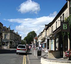
The main shopping area in Newbridge is Chelsea Road, a small area of shops, restaurants and hairdressers. Shops include a bakery, a hardware shop, a SPAR supermarket, a cycle shop and nearby on Newbridge Road a post office.
Bath's major hospital, the Royal United Hospital, is in the north-east of the ward in Combe Park, bordering Weston village. Lansdown Cricket Club's ground is alongside the hospital. Weston Recreation Ground is in Newbridge ward.
Newbridge is the location of Partis College, which was built as large block of almshouses between 1825 and 1827. It is designated as a Grade I listed building.
The National Cycle Network Bristol and Bath Railway Path runs westward from Newbridge to Bristol, and a continuation riverside cycle and footpath runs eastward into central Bath. Newbridge Park and Ride is just off the A4 road on the western edge of the ward, alongside the Newbridge Meadows village green.
The New Bridge
The area is named after the New Bridge over the River Avon outside Bath, built in 1734. This was built to replace a ford that was one of the last impediments to navigation between Bristol and Bath. The bridge had pierced spandrels and arches on either side to allow flood water to pass easily. The bridge was widened and improved in the 1830s to the version that now carries the A4 road from Bath to Bristol out of Newbridge. From about 1902 to 1939 a tram service from central Bath to Newton St Loe operated down Newbridge Road and across the bridge.
Schools
Educationally, Newbridge is part of the North West Bath area of Bath and North East Somerset. This area has 3 primary schools:
and one secondary school:
though at secondary school level many of the girls from the Newbridge area attend Hayesfield Girls' School and many of the boys attend Beechen Cliff School.