
- location Boone, NC - elevation 4,446 ft (1,355 m) Mouth Kanawha River Bridges New River Gorge Bridge | - elevation 3,104 ft (946 m) Length 515 km Country United States of America | |
 | ||
- left Bluestone River, East River - right Little River, Indian Creek, Greenbrier River - location Elk Knob, Watauga County, NC Sources North Fork New River, South Fork New River Similar New River Gorge Bridge, Hawks Nest State Park, Claytor Lake, Blue Ridge Mountains, Allegheny Mountains | ||
The New River, part of the Ohio River watershed, is about 360 mi (515 km) long. The river flows through the U.S. states of North Carolina, Virginia, and West Virginia before joining with the Gauley River to form the Kanawha River at the town of Gauley Bridge, WV.
Contents
- Map of New River Valley WV USA
- CourseEdit
- GeologyEdit
- Natural historyEdit
- HistoryEdit
- RecreationEdit
- Parks forests and trails along the New RiverEdit
- Variant namesEdit
- References
Map of New River, Valley, WV, USA
Much of the river's course through West Virginia is designated as the New River Gorge National River, and the New River is one of the nation's American Heritage Rivers. In 1975, North Carolina designated a 26.5-mile (42.6 km) segment of the river as "New River State Scenic River", by including it in the state's Natural and Scenic Rivers System. The segment was added to the National Wild and Scenic Rivers System the following year.
The origins of the name are unclear. Possibilities include being a new river that wasn't on the Fry-Jefferson map of Virginia, an Indian name meaning "new waters", or the surname of an early settler. Despite its name, the New River is one of the five oldest rivers in the world geologically.
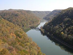
This ancient river begins in the mountains of North Carolina near the Tennessee state line, flows generally northeastward across the Blue Ridge Mountains, Great Appalachian Valley, Ridge and Valley Province, and the Allegheny Front in western North Carolina and Virginia, before turning and following a more northwestward course into West Virginia, where it then cuts through the Appalachian Plateau (in the New River Gorge) to meet the Gauley River and become the Kanawha River in south-central West Virginia. The Kanawha then flows into the Ohio River at Point Pleasant, WV. Much of the river's course is lined with steep cliffs and rock outcrops, particularly in its gorge in West Virginia.
This low-level crossing of the Appalachians, many millions of years old, has long been a biogeographical corridor allowing numerous species of plants and animals to spread between the lowlands of the American East Coast and those of the Midwest; other unusual kinds of plants occur on the gorge's cliffs or rim-top ledges. Portions of this corridor are now also used by various railroads and highways, and some segments of the river have been dammed for hydroelectric power production.
The New River Gorge is not only quite scenic, but also offers numerous opportunities for white-water recreation such as rafting and kayaking. Many open ledges along the rim of the gorge offer popular views, with favorites including Hawks Nest State Park and various overlooks on lands of the New River Gorge National River.
Few highways cross the gorge, with the most dramatic bridge by far being the New River Gorge Bridge on U.S. 19, a steel arch bridge spanning 1,700 feet (518 m), with the roadway 876 feet (267 m) above the average level of the river. This structure is the third-longest single-arch bridge in the world, and is also the world's twelfth-highest vehicular bridge, and the fourth highest in the Americas.
The New River Gorge and the U.S. 19 bridge crossing it are shown on the West Virginia State Quarter, minted in 2005.
CourseEdit
The New River is formed by the confluence of the South Fork New River and the North Fork New River in Ashe County, North Carolina. It then flows north into southwestern Virginia, passing near Galax, Virginia and through a gorge in the Iron Mountains. Continuing north, the river enters Pulaski County, Virginia, where it is impounded by Claytor Dam, creating Claytor Lake. North of the dam the New River accepts the Little River and passes the city of Radford, Virginia before passing through Walker Mountain via a narrow water gap. After flowing north through Giles County, Virginia and the town of Narrows, the river crosses into West Virginia.
The New River is impounded by Bluestone Dam, creating Bluestone Lake in Summers County, West Virginia. The Bluestone River tributary joins the New River in Bluestone Lake. Just below the dam the Greenbrier River joins the New River, which continues its northward course into the New River Gorge. Near the end of the gorge the river flows by the town of Fayetteville, West Virginia. A few miles northwest of Fayetteville, much of the New River's flow is diverted through the 3-mile (4.8 km) Hawks Nest Tunnel for use in power generation. The water re-enters the river just upstream of Gauley Bridge, where the New merges with the Gauley River to form the Kanawha River. The Kanawha is a tributary of the Ohio River, which in turn is a tributary of the Mississippi River.
GeologyEdit
Despite its name, the New River is considered by some geologists to be one of the oldest rivers in the world. The New River flows in a generally south-to-north course, at times cutting across the southwest-to-northeast-trending ridges and geological texture of the Appalachian Mountains, contrasting with the west-to-east flow of most other major rivers to the east and northeast in Virginia and North Carolina. This peculiar direction, together with the river's many cuts through various erosion-resistant Appalachian rocks, reveal that the New River's formation preceded uplift of the Appalachian Mountains themselves.
Natural historyEdit
The New River is home to many species of freshwater game fish including bass, trout, walleye, muskellunge, crappie, bluegill, carp, flathead and channel catfish.
The New River basin also has seven endemic species of fish, which are the: Appalachia darter, Bigmouth chub, Bluestone sculpin, Candy darter, Kanawha darter, Kanawha minnow, and New River shiner.
HistoryEdit
The first recorded European exploration of the New River was the fur trading Batts-Fallam expedition of 1671, sent by Abraham Wood. Variant names of the New River include "Wood's River", after Abraham Wood. Mary Draper Ingles traversed the gorge during her 1755 escape from captivity among the Shawnees. The gorge also has an extensive industrial history, dominated by coal mining, logging and railroads.
RecreationEdit
The New River is spanned by the New River Gorge Bridge near Fayetteville, West Virginia, which is open for BASE jumping on Bridge Day. It is also a very popular river for white water rafting (class II-IV in season, IV-V during the spring run-off), and several commercial outfitters offer a variety of guided trips. Those willing to brave the colder water of spring will be rewarded with a more challenging big-water experience. Near the bridge, there are over 1400 single pitch sport climbs and trails suitable for hiking and mountain biking.
Parks, forests, and trails along the New RiverEdit
Listed from upstream to downstream:
Variant namesEdit
According to the Geographic Names Information System, the New River has also been known as: