
Country Norway District Romerike Area rank 177 in Norway Area 637 km² Local time Friday 2:45 PM Official language form Bokmål | County Akershus Administrative centre Årnes Demonym(s) Nesbu Population 18,022 (2006) Administrative center Årnes Team Nes IK | |
 | ||
Weather 7°C, Wind W at 16 km/h, 46% Humidity | ||
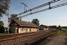
Nes is a municipality in Akershus county, Norway. It is part of the traditional region of Romerike. The administrative centre of the municipality is the village of Årnes.
Contents
Map of Nes, Norway
Name
The municipality (originally the parish) is named after the old Nes farm (Old Norse: Nes which means "headland"), since the first church was built here. The actual nes is the headland made by the two great rivers Glomma and Vorma, which have their meeting point just south of the farm. Prior to 1889, the name was spelled "Næs".
Coat-of-arms
The coat-of-arms is from modern times. They were granted in 1988. The arms show three yellow logs (to represent forestry) on a green background (to symbolize youth and hope). The position of the logs represents the meeting of the rivers Glomma and Vorma, creating the headland of Nes.
History
The parish of Næs was established as a municipality of its own on 1 January 1838 (see formannskapsdistrikt).
Nes Church
Nes Church ruins (Nes kirkeruin) are one of Norway's best preserved church ruins. The old medieval stone church dated from ca 1100 and was extended into a cruciform church in 1697. It was burned in 1854. After the fire the almost completely preserved walls were preserved as ruins. The new Nes church was completed in 1860.
Geography
The municipality borders Eidsvoll, Ullensaker, Sørum, and Aurskog-Høland in Akershus county and Eidskog, Sør-Odal, and Nord-Odal in Hedmark county.
Nes includes many natural attractions, such as parts of the river Glomma, as well as 168 lakes. Elk, beaver, wolf, and lynx can be found here. Hunting and sportfishing are very prevalent.
Eight hundred farms make the area one of the largest producers of wheat in the country.