The Nebraska Department of Roads (NDOR), previously known as the Nebraska Bureau of Roads & Bridges is the state government agency charged with building and maintaining the state and federal highways in the U.S. State of Nebraska. The main headquarters of the agency is located in Lincoln, the capital city. There are eight NDOR district offices located across the state.
The Nebraska Department of Roads differs from other similar state agencies across the country, in that it is a Department of Roads, not a Department of Transportation. The Nebraska Department of Roads does not oversee Nebraska aviation, waterways, motor vehicles, or many other areas that similar agencies in other states have as part of their mission.
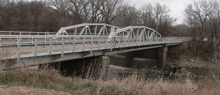
More than 20 bridges and other public works projects built or designed by the Nebraska Department of Roads and its predecessors, including the Nebraska Bureau of Roads & Bridges, have been listed on the U.S. National Register of Historic Places. Many were registered after a 1996 study seeking to inventory historic bridges in Nebraska and pursuant to a Multiple Property Submission titled "Highway Bridges in Nebraska." The projects listed on the National Register include:
Ashland Bridge (1936), Silver Street over Salt Creek, Ashland, Nebraska (Nebraska Bureau of Roads & Bridges)Berry State Aid Bridge (1920-1921), county road over the Niobrara River, 10 miles northeast of Valentine, Nebraska (Nebraska Bureau of Roads & Bridges)Brownson Viaduct (1942), Nebraska Highway Spur 17A over U.S. Route 30 and Union Pacific Railroad tracks, .8 miles northwest of Brownson, Nebraska (Nebraska Bureau of Highways)Bryan Bridge (1932), U.S. Route 20, Valentine, Nebraska (Nebraska Division of Bridge Design)Burwell Bridge (1940-1941), Nebraska Highway 11 over the North Loup River, Burwell, Nebraska (Nebraska Bureau of Roads & Bridges)Columbus Loup River Bridge (1932-1933), U.S. Route 30 over the Loup River, Columbus, Nebraska (Nebraska Bureau of Roads & Bridges)Deering Bridge (1916), county road over School Creek, 2 miles north, 2 miles east of Sutton, Nebraska (Nebraska Bureau of Roads & Bridges)Franklin Bridge (1932, 1935), Nebraska Highway 10 over the Republican River, 1 mile south of Franklin, Nebraska (Nebraska Bureau of Roads & Bridges)Henry State Aid Bridges (1919), Nebraska Highway 86 over the North Platte River, .6 miles south of Henry, Nebraska (Nebraska Bureau of Roads & Bridges)Kilgore Bridge (1915), Nebraska Highway 10 over North Channel Platte River, 7.1 miles southeast of Kearney, Nebraska (Nebraska Dept. of Roads)Lewellen State Aid Bridge (1926-1927), county road over North Platte River, 1 mile south of Lewellen, Nebraska (Nebraska Bureau of Roads & Bridges)Lewis Bridge (1922), county road over the Keya Paha River, 13.6 miles northeast of Springview, Nebraska and Wewela, South Dakota (Nebraska Bureau of Roads & Bridges)Lisco State Aid Bridge (1927-1928), county road over the North Platte River, .6 miles south of Lisco, Nebraska (Nebraska Bureau of Roads & Bridges)Main Street Bridge (1915, 1920), Main St. over W. Papillion Creek, Elkhorn, Nebraska (State of Nebraska)Red Cloud Bridge (1935), Nebraska Highway 281 over the Republican River, 2 miles south of Red Cloud, Nebraska (Nebraska Highway Dept.)Roscoe State Aid Bridge (1934-1935), State Link 51B over the South Platte River, .5 miles southeast of Roscoe, Nebraska (Nebraska Bureau of Roads & Bridges)Saddle Creek Underpass (1934), U.S. Route 6 (Dodge St.) over Saddle Creek Rd., Omaha, Nebraska (State of Nebraska)Stewart Bridge (1915), county road over Big Sandy Creek, 1 mile east and 8 miles north of Oak, Nebraska (Nebraska Highway Dept.)Sutherland State Aid Bridge, county road over the North Platte River, 4.2 miles north of Sutherland, Nebraska (Nebraska Bureau of Roads & Bridges)Tekamah City Bridge (1934), U.S. Route 75 over Tekamah Creek, Tekamah, Nebraska (Nebraska Dept. of Roads)York Subway (1938-1939), 14th and 15th Streets and Burlington Northern Railroad tracks over U.S. Route 81, York, Nebraska (Nebraska Bureau of Roads & Bridges)