
Comarca Rioja Media Elevation 512 m Province La Rioja Local time Thursday 12:21 AM | Autonomous community La Rioja Time zone CET (UTC+1) Area 28.49 km² Population 2,955 (2014) | |
 | ||
Weather 4°C, Wind W at 5 km/h, 76% Humidity | ||
Navarrete is a municipality of the autonomous community of La Rioja, Spain, with a population of 2,660 (as of January 2006) and an area of 28.49 km2. Named a conjunto histórico of Spain, Navarrete is located between Logroño and Nájera on the Way of St. James, a medieval pilgrim route.
Contents
- Map of 26370 Navarrete La Rioja Spain
- Economy
- Geography
- History
- Places of interest
- Buildings and monuments
- Demography
- References
Map of 26370 Navarrete, La Rioja, Spain
Demographic evolution of Navarrete, during the 20th century.
Economy
Rioja wine is very important to Navarrete's economy. There are still some old potteries in the upper part of the town, although the industry has relocated to the lower part of town, next to the communication routes.
Geography
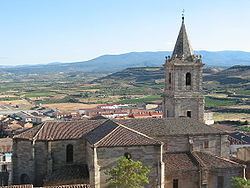
The historic centre of the town is built on a hill called Tedeón (512 m), from which the town has since expanded. The municipality borders Fuenmayor to the north, Logroño and Lardero to the east, Entrena, Medrano, Hornos de Moncalvillo, and Sotés to the south, and Huércanos and Cenicero to the west.
History
The origin of the name Navarrete is uncertain. Navarrete was founded by the King of Castile as part of a plan to defend his borders and the name appears to have some relation to the neighbouring Kingdom of Navarre. One theory notes that the word "Nafarrate" in Basque means "Door of Navarre"; the later castellanization of the name would give rise to the present spelling.
Alfonso VIII of Castile proposed to the inhabitants of the old villages of the zone that they relocate in a defensive place. These villages were known by the name of Corcuetos and their names were: San Llorente, San Antolín, San Pedro and Nuestra Señora del Prado. Their population settled around a castle raised on Tedeón hill, thus founding the new villa of Navarrete. The castle was fortified and protected with a small wall, that enclosed the settlement and it defended it from the possible attacks that threatened from the north.
In 1192 important fueros were granted to the inhabitants of the new settlement. These fueros, or charter, gave rise to the use in common of river waters and the collective exploitation of grass lands and woods to the east of the town. The charter also allowed for the establishment of local markets and fairs. Thanks to these privileges, the villa reached a great importance.
In 1367 a battle took place in the locality which is sometimes called the Battle of Navarrete, but is better known as the Battle of Nájera.
Places of interest
The historic centre is protected as a Conjunto histórico.
Buildings and monuments
Demography
Demographic evolution of Navarrete, during the 20th century.