
West end: Pindwara, Rajasthan | Length 1,007 km | |
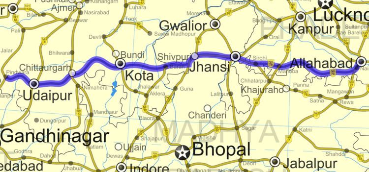 | ||
East end: NH 27 south of Allahabad States: Rajasthan: 480 km (300 mi)
Madhya Pradesh: 60 km (37 mi)
Uttar Pradesh: 467 km (290 mi) Primary
destinations: Pindwara - Udaipur - Chittaurgarh - Kota - Shivpuri - Jhansi - Banda - Allahabad | ||
National Highway 76 or NH 76 is a National Highway in India that links Allahabad in Uttar Pradesh with Pindwara in Rajasthan. This 1,007 km (626 mi) long highway passes through Udaipur, Kota, Shivpuri, Jhansi and Banda.
Contents
- Map of NH 76 Panwari Uttar Pradesh 210429
- National Highways Development Project
- National Highway 76 Extension
- References
Map of NH 76, Panwari, Uttar Pradesh 210429
Of its total length, the National Highway 76 traverses 467 km (290 mi)in Uttar Pradesh, 60 km (37 mi) Madhya Pradesh and 480 km (300 mi) in Rajasthan.
National Highways Development Project
National Highway 76 Extension
National Highway 76 has an extension of 90 km (56 mi), deviated 19 km (12 mi) before Allahabad. It is called NH 76 Extn., route being 19 km (12 mi) of NH 76 to Mirzapur. Some of the road passes through small hills. An important point to note while travelling via this Highway is that traffic is very sparse (specially between Udaipur-Shivpuri) and you do not find any motels or roadside dhabas.