
Country Japan District Kiso Area 215.9 km² Population 4,248 (Oct 2016) | Region Chūbu (Kōshin'etsu) Phone number 0264-57-2001 Local time Monday 10:05 AM Prefecture Nagano Prefecture | |
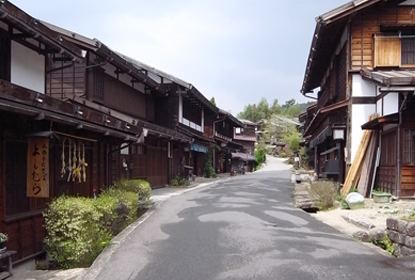 | ||
Time zone Japan Standard Time (UTC+9) Address 3668-1 Yomikaki, Nagiso-machi, Kiso-gun, Nagano-ken 399-5301 Weather 8°C, Wind SW at 6 km/h, 28% Humidity Points of interest Tsumago‑juku, Nagisocho Museum, Kōtoku‑ji Temple, Mt Nagiso, Tenpaku Park | ||
Nagiso (箕輪町, Nagiso-machi) is a town located in Kiso District in southwestern Nagano Prefecture, in the Chūbu region of Japan. As of 1 October 2016, the town had an estimated population of 4,248 and a population density of 19.7 persons per km². Its total area was 215.93 square kilometres (83.37 sq mi). Nagiso is listed as one of The Most Beautiful Villages in Japan
Contents
- Map of Nagiso Kiso District Nagano Prefecture Japan
- Geography
- Surrounding municipalities
- History
- Education
- Railway
- Highway
- Local attractions
- References
Map of Nagiso, Kiso District, Nagano Prefecture, Japan
Geography
Nagiso is located in the Kiso Valley of southwestern Nagano Prefecture, bordered by Gifu Prefecture to the west.
Surrounding municipalities
History
The area of present-day Nagiso was part of ancient Shinano Province. During the Edo period, the area developed as series of post stations on the Nakasendō highway connecting Edo with Kyoto. The villages of Yomikaki, Tsumagoi and Tadachi merged to form the town of Nagiso on May 1, 1968.
Education
Nagiso has one public elementary schools and one public middle school operated by the town government, and one high school operated the Nagano Prefectural Board of Education.