
Official name Đập Na Hang Location Tuyên Quang Province Opening date 2008 Height 92 m Construction began 2002 | Status Operational Type of dam Rock-fill Province Tuyên Quang Province | |
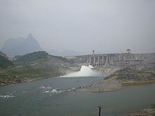 | ||
The Na Hang Dam (also known as Tuyên Quang Dam) is a hydroelectric dam on the Gâm River near Pác Tạ Mountain in Tuyên Quang Province, Vietnam.
Map of Na Hang Dam, tt. Na Hang, Na Hang, Tuy%C3%AAn Quang, Vietnam
Construction began on December 22, 2002 and the first unit was commissioned in March 2008 followed by the two other units by end of 2008. The power plant has a capacity of 342 MW (the second largest in the north), and has an energy generating potential of 1,200 GWh per year. The project's estimated approved cost was US$490 million. The project, as built, has a 92 metres (302 ft) rock fill dam and 718 metres (2,356 ft) long (crest length), called the Na Hang Dam. It has a gross storage capacity of 2.3 billion cubic metres (1,900,000 acre·ft) (including 1 billion cubic metres (810,000 acre·ft) of flood storage) on the Gâm River.
Construction of the dam inundated five communes involving about 4,000 households from an area of almost 8,000 hectares. Tay and Dao indigenous peoples were the majority in the Na Hang district when the dam was constructed. There are human rights concerns about missing compensation for relocation, with claims that infrastructure to support resettlement sites as agreed has been neglected by provincial authorities.
The local government has tried to take advantage of the Na Hang District hydroelectric project for tourism.