
Sponsored by Mrs. H. Arnold Karo Homeport Seattle, Washington Length 89 m Endurance 1.2 months | Commissioned 30 April 1960 Launched 25 April 1959 Range 25.33536 million m | |
 | ||
Name USC&GS Surveyor (OSS 32) Namesake A surveyor is a member of the profession of surveying, which determines positions on the earth's surface Fate Transferred to National Oceanic and Atmospheric Administration 3 October 1970 Builder National Steel and Shipbuilding Company | ||
NOAA Ship Surveyor (S 132) was an oceanographic survey ship in commission in the National Oceanic and Atmospheric Administration (NOAA) from 1970 until 1995. Prior to her NOAA career, she was in commission in the United States Coast and Geodetic Survey from 1960 to 1970 as USC&GS Surveyor (OSS 32). She was the second and last Coast and Geodetic Survey ship named Surveyor and has been the only NOAA ship thus far to bear the name.
Contents
Construction and characteristics
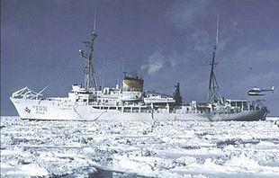
Surveyor was built as an "ocean survey ship" (OSS) for the U.S. Coast and Geodetic Survey by National Steel and Shipbuilding Company in San Diego, California, and launched on 25 April 1959, sponsored by Mrs. H. Arnold Karo. She was the last steam-powered ship built for the Coast and Geodetic Survey, and the first to be equipped with a deep-water multi-beam echosounder. Her construction marked the beginning of a major effort to modernize the Coast and Geodetic Survey fleet and make it capable of conducting operations worldwide.
In addition to the deep-water echosounder, Surveyor had a shallow-water echosounder, a stabilized mapping sonar system, a Hydroplot data-processing system, a data-processing computer, seismic reflection profile processors, seismic reflection profile processors, and an extensive suite of navigation equipment, as well as a wet and dry oceanography laboratory, a gravimetric laboratory, and a photographic laboratory.
Operational career
USC&GS Surveyor (OSS 32) was commissioned into service with the Coast and Geodetic Survey on April 30, 1960. When NOAA was created on 3 October 1970 and took over the Coast and Geodetic Survey's fleet, she became a part of the NOAA fleet as NOAAS Surveyor (S 132).
Based at Seattle, Washington, and nicknamed "Old Workhouse," Surveyor spent her career in the Pacific Ocean and Arctic Ocean, operating as far north as the Beaufort Sea off Alaska and as far south as the Palmer Peninsula in Antarctica; she conducted hydrographic surveys in such widely separated areas as Norton Sound in Alaska and American Samoa. She was the primary ship for studying the Alaskan Arctic for the Outer Continental Shelf Environmental Assessment Program (OCSEAP) and for studying Antarctic Marine Living Resources (AMLR.) She also conducted multi-beam echosounder surveys along the United States West Coast, off the southern coast of Alaska, throughout the Juan de Fuca Ridge area off the coast of Washington and British Columbia, and in Hawaiian waters. She discovered Axial Seamount on Endeavor Ridge, a seamount that apparently has been split in half by seafloor spreading.
On March 6, 1980, while Surveyor was tied to a pier in San Francisco, California, one of her crewmen fell over the side into the water between the ship and the pier. Without hesitation another crewman, Able-Bodied Seaman Wallace K. Kanahele, leaped into the water, rescued the man—who was suffering from hypothermia—and brought him to a small boat which had been lowered by another vessel. For saving his shipmate's life, Kanahele received the Department of Commerce Gold Medal in 1980.
NOAA decommissioned Surveyor in a ceremony in Seattle on September 29, 1995.
Post-decommissioning
After her decommissioning, Surveyor was moved to Seattle's Lake Washington Ship Canal, where she was decontaminated near the Ballard Locks by USS, Ltd., of Bend, Oregon. As part of the contract for decontaminating Surveyor, USS took possession of her and arranged for her sale to a private party.
After spending several years near the Ballard Locks, Surveyor was moved to the Tyee Marina in Commencement Bay at Tacoma, Washington, where she remained as of April 2015, apparently serving as a windbreak for the marina under the designation OSS 2. She is registered with the United States Coast Guard through 2016.
Commemoration
The Surveyor Fracture Zone, Surveyor Gap, and Surveyor Seachannel all are named for Surveyor.
Further information
Further information on Surveyor's status can be found in the U.S. Coast Guard's registration database, the Port State Information Exchange, by entering the callsign "WTES" in the search box.