
Country United States River mouth Long Island Sound | Main source Connecticut Length 3.4 mi (5.5 km) | |
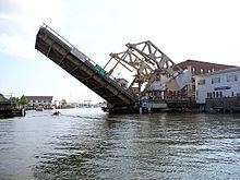 | ||
Bridges Mystic River Bascule Bridge, Mystic River Railroad Bridge | ||
The Mystic River is a 3.4-mile-long (5.5 km) estuary in the southeast corner of the U.S. state of Connecticut. Its main tributary is Whitford Brook. It empties into Fishers Island Sound, dividing the village of Mystic between the towns of Groton and Stonington. Much of the river is tidal. The Mystic River was the location of three large shipbuilding firms during the 19th-century, and it is now the home of the Mystic Seaport maritime museum. The name Mystic, as the modern spelling has it, is derived from the Pequot term "missi-tuk", describing a large river whose waters are driven into waves by tides or wind, according to the Mystic River Historical Society.
Contents
Map of Mystic River, Connecticut, USA
HistoryEdit
The Pequot Indians built their first village, called the Siccanemos, overlooking the western bank of the Mystic River. The only written records describe this village as existing in the year 1637. There were many hostilities and power struggles between the Native American tribes and English settlers during this time. On May 26, 1637, a military force under the command of John Mason and John Underhill attacked and destroyed the Pequot village, killing almost everyone and burning the village to the ground.