
Population 221 (2011 census) State electorate(s) Buninyong Local time Thursday 8:07 PM | Myrniong Lerderderg Federal division Division of Ballarat | |
 | ||
Weather 16°C, Wind SE at 19 km/h, 86% Humidity | ||
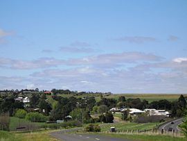
Myrniong (/ˈmɜːrnɒŋ/, locally [ˈmɜːnɔŋ]) is a town in Victoria, Australia. The town is located near the Western Freeway, 72 kilometres (45 mi) north west of the state capital, Melbourne and 15 kilometres (9 mi) west of Bacchus Marsh. Situated close by the Lerderderg River, at the 2011 census, Myrniong had a population of 221. The town is in the eastern area of Shire of Moorabool local government area.
Map of Myrniong VIC 3341, Australia
Myrniong was named for the murrnong plant the Aboriginal word for yam daisy, a popular food source. European settlement began in around 1850 with local farmers producing wheat for hungry gold miners at nearby Blackwood. Later production concentrated on beef and dairy.
The Post Office opened on 6 September 1858 as Pentland Hills, was renamed Myrniong in 1872 and closed in 1970.
Myrniong is known for its many bluestone buildings, including the historic Plough Hotel, established in 1859, and the Anglican church. Other attractions in the area include Pykes Creek Reservoir, providing water to the market gardens in nearby Bacchus Marsh and Mount Blackwood, an extinct volcano offering panoramic views over the Wombat State Forest. and Werribee Gorge State Park. An Historic Car Sprint is held in the town each April, and in March an annual music event, 'Myrniong Music in The Park', is a fixture on the Blues music Calendar.