
OS grid reference SE650526 Ceremonial county North Yorkshire Sovereign state United Kingdom Local time Wednesday 2:30 AM | Civil parish Murton Country England Population 668 (2011) UK parliament constituency York Outer | |
 | ||
Region Yorkshire and the Humber Weather 4°C, Wind E at 13 km/h, 92% Humidity | ||
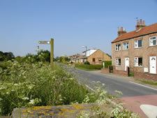
Murton is a small village and a civil parish in the unitary authority of the City of York in North Yorkshire, England that is located on the outskirts of York. To the west there is the A64 and the village of Osbaldwick, to the south the A166 road to Bridlington, to the north the village of Stockton-on-the-Forest, and to the east the villages of Holtby and Warthill.
Contents
Map of Murton, UK
According to the 2001 census the parish had a population of 423, increasing to 668 in the 2011 Census. Before 1996 it had been part of the Ryedale district.
The village has around a hundred properties ranging from traditional large country houses to more modern buildings.
The village is home to the Yorkshire Museum of Farming at Murton Park. Here there is a small railway track which is the remains of the Derwent Valley Light Railway. Trains are run on Sundays and bank holidays. The village has a local pub called the Bay Horse. The York Livestock Centre is also located in Murton.
The village has a small church named after St James, which is linked with St Thomas' Church in Osbaldwick.
Transport
East Yorkshire Motor Services provide a bus service to the village of Murton from Pocklington to York.