
Population 5,869 (2006 census) Postcode(s) 6027 | Established 1950s Postal code 6027 | |
 | ||
Location 25 km (16 mi) from Perth | ||
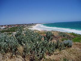
Mullaloo is a northern coastal suburb of Perth, Western Australia, within the City of Joondalup.
Contents
Map of Mullaloo WA 6027, Australia
History
Mullaloo is named after an Aboriginal word, believed to mean "place of the rat kangaroo". It was first recorded in 1919 as Moolalloo Point, but the spelling was later changed to Mullaloo. Urban development began in the late 1950s.
Today
The Mullaloo Surf Life Saving club patrols around 4.5 km of beach between Pinnaroo Point and Whitfords Point, between September and April. The club has row teams, swim teams, board teams and sprint teams.
Mullaloo has two schools, Mullaloo Beach Primary School and Mullaloo Heights Primary School. Enrolment currently stands at 272 at Mullaloo Heights.
References
Mullaloo, Western Australia Wikipedia(Text) CC BY-SA