
County Marin Area codes 415/628 Area 128 ha Zip code 94965 | FIPS code 06-49950 Elevation 95 m Population 310 (1 Apr 2010) | |
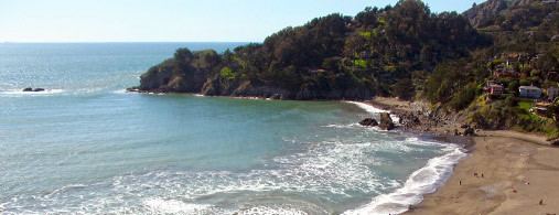 | ||
Hwy 1 john muir beach california
Muir Beach is a census designated place (CDP), unincorporated community, and beach that is located 16.5 miles (26.6 km) northwest of San Francisco in western Marin County, California, United States. It is named for John Muir. The population was 310 at the 2010 census. The community itself flanks the northwest side of the beach.
Contents
- Hwy 1 john muir beach california
- Map of Muir Beach CA USA
- Geography
- 2010
- 2000
- Education
- Local government
- References
Map of Muir Beach, CA, USA
Located about 2 miles (3 km) from the entrance to Muir Woods National Monument, the beach is about 1000 feet (305 m) long and 200 feet (61 m) wide, with coarse sand and several large boulders. Redwood Creek empties into the beach. There is a parking lot at the beach, which is accessible via a footbridge.
The beach was formerly called Big Lagoon after a freshwater lagoon that was located where the parking lot is now. Damage from 20th century dairy farms interfered with the flow of the creek and the lagoon.
Geography
According to the United States Census Bureau, the CDP has a total area of 0.5 square miles (1.3 km²), all of it land.
The beach is one of the cleanest in the state.
2010
The 2010 United States Census reported that Muir Beach had a population of 310. The population density was 629.0 people per square mile (242.9/km²). The racial makeup of Muir Beach was 283 (91.3%) White, 5 (1.6%) African American, 1 (0.3%) Native American, 12 (3.9%) Asian, 1 (0.3%) from other races, and 8 (2.6%) from two or more races. Hispanic or Latino of any race were 7 persons (2.3%).
The Census reported that 95.8% of the population lived in households and 4.2% lived in non-institutionalized group quarters.
There were 141 households, out of which 27 (19.1%) had children under the age of 18 living in them, 79 (56.0%) were opposite-sex married couples living together, 4 (2.8%) had a female householder with no husband present, 3 (2.1%) had a male householder with no wife present. There were 11 (7.8%) unmarried opposite-sex partnerships, and 1 (0.7%) same-sex married couples or partnerships. 39 households (27.7%) were made up of individuals and 11 (7.8%) had someone living alone who was 65 years of age or older. The average household size was 2.11. There were 86 families (61.0% of all households); the average family size was 2.47.
The population was spread out with 38 people (12.3%) under the age of 18, 10 people (3.2%) aged 18 to 24, 56 people (18.1%) aged 25 to 44, 138 people (44.5%) aged 45 to 64, and 68 people (21.9%) who were 65 years of age or older. The median age was 52.6 years. For every 100 females there were 102.6 males. For every 100 females age 18 and over, there were 106.1 males.
There were 162 housing units at an average density of 328.7 per square mile (126.9/km²), of which 73.8% were owner-occupied and 26.2% were occupied by renters. The homeowner vacancy rate was 1.0%; the rental vacancy rate was 2.6%. 75.2% of the population lived in owner-occupied housing units and 20.6% lived in rental housing units.
2000
As of the census of 2000, there were 295 people, 131 households, and 69 families residing in the CDP. The population density was 596.8 people per square mile (232.4/km²). There were 144 housing units at an average density of 291.3 per square mile (113.5/km²). The racial makeup of the CDP in 2010 was 89.7% non-Hispanic White, 0.8% non-Hispanic African American, 3.9% Asian, and 2.6% from two or more races. Hispanic or Latino of any race were 2.3% of the population.
There were 131 households out of which 19.1% had children under the age of 18 living with them, 45.0% were married couples living together, 5.3% had a female householder with no husband present, and 46.6% were non-families. 30.5% of all households were made up of individuals and 7.6% had someone living alone who was 65 years of age or older. The average household size was 2.22 and the average family size was 2.67.
In the CDP, the population was spread out with 14.2% under the age of 18, 2.7% from 18 to 24, 26.1% from 25 to 44, 46.8% from 45 to 64, and 10.2% who were 65 years of age or older. The median age was 48 years. For every 100 females there were 90.3 males. For every 100 females age 18 and over, there were 91.7 males.
The median income for a household in the CDP was $125,402, and the median income for a family was $152,174. The per capita income for the CDP was $66,476. None of the families and 10.5% of the population were living below the poverty line.
Education
Muir Beach is in the Mill Valley School District, Tamalpais Union High School District, and the Marin Community College District. Students attend public schools in or near Mill Valley at Tamalpais Valley Elementary School (kindergarten - grade 5), Mill Valley Middle School (grades 6 - 8), and Tamalpais High School (grades 9 - 12).
Local government
Muir Beach is unincorporated, receiving general government services from Marin County, including law enforcement, land-use planning, library, public health, and code enforcement. A special district, the Muir Beach Community Services District, provides local services, including fire protection, water, road maintenance, and recreation. The District has a board of directors, with five members elected to four-year terms. The District includes all of the Muir Beach CDP, plus Green Gulch Farm. (See map of MBCSD.)