
District uMkhanyakude Established 1903 Area code 035 | Municipality Mtubatuba Postal code (street) 3935 Local time Tuesday 3:10 AM | |
 | ||
Weather 21°C, Wind W at 5 km/h, 88% Humidity | ||
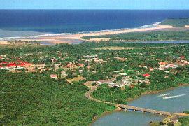
Mtubatuba is a town north of Richards Bay close to the entrance of the iSimangaliso Wetland Park (previously Greater St Lucia Wetland Park) in KwaZulu-Natal, South Africa.
Map of Mtubatuba, 3935, South Africa
Town some 55 km south-south-west of Hluhluwe and 28 km west of St Lucia. Administered by a health committee since 1950. The name, formerly spelt Matubatuba, is Zulu for ‘creator of opportunities’, referring to a chief of the Mkwananzi tribe who died here in 1954.
The town's early years were hampered by flooding. An additional setback occurred during World War I: a ship carrying essential parts of what was to be the town's first sugar mill was torpedoed. The mill was eventually constructed in 1916 at nearby Riverview. Its township is KwaMsane.
References
Mtubatuba Wikipedia(Text) CC BY-SA