
Length 445 km Basin area 23,300 km² Source Lake Mstino Bridges Belelyubsky Bridge | Discharge 200 m³/s Mouth Lake Ilmen Country Russia | |
 | ||
Main source Lake Mstino
150 m (490 ft) River mouth Lake Ilmen
18 m (59 ft) Basin size 23,300 km (9,000 sq mi) | ||
The Msta (Russian: Мста) is a river in Vyshnevolotsky, Udomelsky, and Bologovsky Districts of Tver Oblast and in Borovichsky, Okulovsky, Lyubytinsky, Malovishersky, Krestetsky, and Novgorodsky Districts, as well as in the town of Borovichi of Novgorod Oblast of Russia. It is a tributary of Lake Ilmen. It is 445 kilometres (277 mi) long, and the area of its basin 23,300 square kilometres (9,000 sq mi). The principal tributaries of the Msta are the Berezayka (left), the Uver (right), and the Kholova (left). The town of Borovichi and the urban-type settlement of Lyubytino are located on the banks of the Msta.
Map of Msta River, Novgorod Oblast, Russia
The source of the Msta is in Lake Mstino in the Valdai Hills immediately north of the town of Vyshny Volochyok. The river flows north, accepts the Berezayka from the left, and enters Novgorod Oblast. There, it accepts the Uver from the right and turns northwest. Downstream from the town of Borovichi, it forms the border between Borovichsky and Okulovsky District, and still downstream between Okulovsky and Lyubytinsky District. It departs from the border to the north, and downstream of the settlement of Lyubytino sharply turns southwest. It makes one more curve at the border with Krestetsky District and has its mouth downstream of the settlement of Proletariy.
The river basin of the Msta is vast and comprises the eastern part of Novgorod Oblast and the areas in the northern part of Tver Oblast. The towns of Borovichi, Bologoye, Udomlya, Okulovka, and Valday lie in the river basin of the Msta.
Up to mid-19th century, Msta, which belongs to the river basin of the Neva, had been a part of an important water trade route connecting the Baltic and Black seas due to the very short distance between the Tsna, then the tributary of Lake Mstino, and the Tvertsa, a left tributary of the Volga. The portage between these lakes existed from the Middle Ages. In the beginning of the 18th century, Vyshny Volochyok Waterway was constructed, connecting the Msta and the Tvertsa. By the middle of the 19th century, after opening of the Volga-Baltic Waterway and the Moscow-Saint Petersburg Railway, the significance of the Msta River as a transport route has decreased.
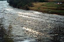
It is also notable for the rapids in a 30-kilometre (19 mi) section between Opechensky Posad and Borovichi, and is a popular rafting route.
The lowest 134 kilometres (83 mi) of the Msta, downstream of the selo of Mstinsky Most, are listed as navigable in the State Water Register of Russia.