
Country Ukraine District Zboriv Raion Time zone EET (UTC+2) Area 1,625 km² | Province Ternopil Oblast Elevation 355 m (1,165 ft) Postal code 47235 | |
 | ||
Mshanets (Ukrainian: Мшане́ць) is a village in the Zboriv Raion, Ternopil Oblast of Western Ukraine. From 1975 to 1990 the village was called Peremozhne. The area of the village is 1,625 km2 and it has a population of 728 people. The local government is the Mshanetska village council, and includes the villages Ditkivtsi, Homivka and farmstead Manyuky.
Contents
Map of Mshanets', Ternopil Oblast, Ukraine
Geography
The village is located on the shores of the Verkhovynka river (it is the left tributary of the Seret River) at an altitude of 355 metres (1,160 ft) above sea level, which is in eastern of Zboriv Raion. It is situated 26 kilometres (16 mi) from the regional center Ternopil, 40 kilometres (25 mi) from the district center Zboriv (through urban-type settlement Zaliztsi) and 52 kilometres (32 mi) from Brody.
History
Mshanets village was first mentioned in 1463. In 1518 the village became the property of Konstanty Ostrogski, a magnate of the Grand Duchy of Lithuania and later a Grand Hetman of Lithuania.
The village was largely destroyed at the time of the First World War. The whole village was evacuated and houses were destroyed. People departed to different parts of Ukraine.
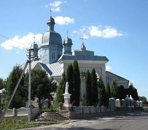
Churches and religion
Mshanetska Parish of the Ukrainian Greek Catholic Church, Temple of St. Archangel Michael (1794, stone, reconstructed).